
Councillor
(as addressed)
The next Council Meeting will be
held in the Council Chamber, Braeside Avenue, Ringwood, on Monday 12 December
2016, commencing at 7.30pm and your presence is requested.
Yours faithfully

Steve Kozlowski
CHIEF EXECUTIVE OFFICER
|

|
Council
Chamber
is fitted with a Hearing Aid Induction Loop
Switch
Hearing Aid to ‘T’ for Reception
|
|
City
Offices
|
Braeside
Avenue, Ringwood, 3134
|
|
Postal
|
PO
Box 156, Ringwood 3134
DX
38068, Ringwood
|
|
Telephone
|
1300
88 22 33
|
|
Facsimile
Email
Web
Service
Centres
|
Translating and Interpreting Service (TIS): 131 450
National Relay
Service (NRS): 133 677
(03)
9298 4345
maroondah@maroondah.vic.gov.au
www.maroondah.vic.gov.au
Croydon: Civic
Square
Ringwood: Realm
179 Maroondah Highway Ringwood
|
1. Prayer
2. Acknowledgment
of Country
3. Apologies
4. Declaration
of Interests
5. Confirmation of
Minutes of the Ordinary Council Meeting held on Monday 21 November 2016.
6. Public
Questions
7. Officers’
Reports
Director Corporate Services
1. Attendance Report 4
2. Reports of Assembly
of Councillors 6
3. The Maroondah
Foundation - New Board Members 15
Director Operations, Infrastructure & Leisure
1. Community Facilities
Dedication Nominations 18
2. Exeter Road, Croydon
North - Speed Limit and Traffic Calming Measures Petition 25
Director Planning & Community
1. Planning Scheme Amendment
C97 - Heathmont Activity Centre Structure Plan 31
2. Planning Scheme
Amendment C96 - Ringwood East Activity Centre Structure Plan 53
3. Know Your Council
Website - 2015/16 Local Government Performance Reporting Framework (LGPRF)
Results 73
4. Fenced Dog Parks for
Maroondah 80
8. Documents for
Sealing
1. Village School Licence
Agreement and Transfer of Land 93
9. Motions to Review
10. Late
Item
11. Requests
/ Leave of Absence
12. In
Camera
Director Corporate Services
1. Tender Evaluation
Report - Contract 20801 General Valuation 2018 & Related Services
|
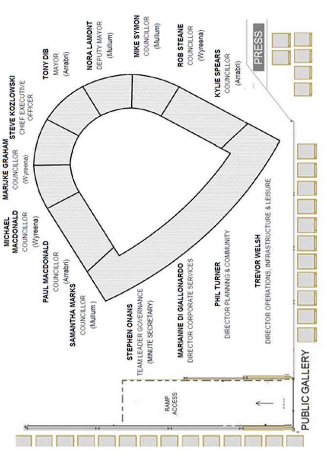
DIRECTOR Corporate Services – Marianne Di Giallonardo
|
|
|
|
Attendance Report
|
Item 1
|
Purpose
To provide an opportunity for Councillors to report on
Council activities undertaken since the last Ordinary Meeting of Council and
forthcoming ward activities.
Strategic /
policy issues
The following directions contained in Maroondah 2040:
Our Future Together and the Council Plan 2013-2017 (Year 4: 2016-2017) provide
the strategic framework that underpins the purpose of this report.
Outcome Area: A well governed and
empowered community
Our Vision: Maroondah is an effectively empowered community that is actively engaged
in Council decision making through processes that ensure their voice is heard
and considered. Council provides strong and responsive leadership,
ensures transparent processes and works with the community to advocate and
champion their needs
Key Directions 2013 – 2017:
8.1 Provide
enhanced governance that is transparent, accessible, inclusive and accountable
Background
Not Applicable
Issue /
discussion
It is intended that the Mayor and Councillors be given the
opportunity to present a verbal or written report updating Council on the
activities they have undertaken in their role as Councillors and forthcoming
ward activities.
Financial /
economic issues
Not Applicable
Environmental
/ amenity issues
Not Applicable
Social /
community issues
Not Applicable
Community
consultation
Not Applicable
Conclusion
It is appropriate that Councillors formally report to
Council upon the activities they have undertaken in their role as Councillors.
Attachments
Not Applicable
CONFIDENTIALITY
Not Applicable
|
RECOMMENDATION
That COUNCIL RECEIVES AND NOTES
THE REPORTS AS PRESENTED BY
COUNCILLORS
|
|
DIRECTOR Corporate Services – Marianne Di Giallonardo
|
|
|
|
Reports of Assembly of
Councillors
|
Item 2
|
Purpose
To present the ‘Public Record’ of those Assembly
of Councillors briefings which are attended by all Councillors and generally
held on Monday evenings at the City Offices Ringwood, usually two weeks prior
to the formal Council Meeting, and to note the issues discussed.
Strategic /
policy issues
The following directions contained in Maroondah 2040:
Our Future Together and the Council Plan 2013-2017 (Year 4: 2016-2017) provide
the strategic framework that underpins the purpose of this report.
Outcome Area: A well governed and empowered
community
Our Vision: Maroondah is an effectively empowered community that is
actively engaged in Council decision making through processes that ensure their
voice is heard and considered. Council provides strong and responsive
leadership, ensures transparent processes and works with the community to
advocate and champion their needs
Key Directions 2014 –
2015:
8.1 Provide
enhanced governance that is transparent, accessible, inclusive and accountable
Background
An Assembly of Councillors, as defined under the Local
Government Act 1989 [s.3], is a planned or scheduled meeting, comprising at
least five (5) Councillors and one (1) member of Council staff, that considers
matters that are intended or likely to be:
· the
subject of a decision of the Council; or
· subject
to the exercise of a delegated function, duty or power of Council
Examples of an Assembly of Councillors may include:
· Councillor
Briefings (which are attended by all Councillors and generally held on Monday
evenings),
· On-site
inspections,
· Consultative
Meetings with residents, developers, consultants,
· Panel
Hearings conducted under s223 of the Act,
· Meetings
with local organisations, Government Departments, statutory authorities, and
local politicians
Issue /
discussion
As part of decision making processes at Maroondah, it is
essential that Councillors are briefed on a range of issues which come before
Council for consideration. As a means of providing this information,
Assembly of Councillors briefings are conducted.
Assemblies are also attended by Council Officers, and
sometimes other specific advisors, to provide Councillors with a detailed
knowledge and understanding of issues under consideration to a level of detail
that would inhibit timely decision-making, that would not be possible in an
open Council meeting, where decision-making related debate is governed by
strict meeting procedures.
The intent of this report is to present the ‘Public
Record’ of those Assembly of Councillors briefings which are attended by
all Councillors and generally held on Monday evenings, and to note the items
discussed. This information is already available to the public upon
request in accordance with the Local Government Act [s.80A].
This report and attachments formally table the information
items previously covered by Councillors.
The ‘Public Record’ of the Assembly of
Councillors briefings held on 21 November 2016, 23 November 2016, 28 November
2016, 30 November 2016 and 5 December 2016 are attached for information.
The items contained therein were noted.
Financial /
economic issues
Not Applicable
Environmental
/ amenity issues
Not Applicable
Social /
community issues
Not Applicable
Community
consultation
Not Applicable
Conclusion
Assembly of Councillors briefings are important forums for
advice and discussion, on what are often complex issues facing the
municipality, in the lead up to formal decisions being made by Councillors at
Council Meetings. At Assemblies, or outside them, Councillors also have
the opportunity of requesting additional information to assist in the decision
making process.
It is appropriate that the ‘Public Record’ of
those Assembly of Councillors briefings which are attended by all Councillors
and generally held on Monday evenings at the City Offices Ringwood, usually two
weeks prior to the formal Council Meeting, be noted at a formal meeting of
Council.
Attachments
|
1.⇩
|
2016
November 21 - Assembly of Councillors Public Record
|
|
2.⇩
|
2016
November 23 - Assembly of Councillors Public Record
|
|
3.⇩
|
2016
November 28 - Assembly of Councillors Public Record
|
|
4.⇩
|
2016
November 30 - Assembly of Councillors Public Record
|
|
5.⇩
|
2016
December 05 - Assembly of Councillors Public Record
|
CONFIDENTIALITY
Not Applicable
|
RECOMMENDATION
THAT COUNCIL RECEIVES AND NOTES THE PUBLIC
RECORD OF THE ASSEMBLY OF COUNCILLORS BRIEFINGS HELD ON 21 November 2016, 23
November 2016, 28 November 2016, 30 november 2016 and 5 december 2016
|
|
ATTACHMENT No: 1 - 2016 November 21 - Assembly of Councillors Public Record
|
|
Item 2
|

ASSEMBLY OF COUNCILLORS – PUBLIC RECORD
|
Assembly Details:
|
|
|
|
|
|
|
|
Date: Monday 21
November 2016
|
Time: 6:00pm
|
Location: Meeting Room 4, Braeside Avenue, Ringwood
|
|
|
|
|
|
Attendees:
|
|
|
|
|
|
|
|
Councillors
|
|
|
|
Cr Tony Dib, JP
|
Cr Samantha Marks
|
Cr Kylie Spears
|
|
Cr Marijke Graham
|
Cr Michael Macdonald
|
Cr Rob Steane
|
|
Cr Nora Lamont
|
Cr Paul Macdonald
|
Cr Mike Symon
|
|
|
|
|
|
Council Officers:
|
|
|
|
Steve Kozlowski
|
Chief Executive Officer
|
|
Marianne Di Giallonardo
|
Director Corporate Services
|
|
Phil Turner
|
Director Planning & Community
|
|
Trevor Welsh
|
Director Operations, Infrastructure & Leisure
|
|
Andrew Fuaux
|
Manager Planning, Health & Local Laws Item 2
|
|
Chris Zidak
|
Manager Business & Development Item 3
|
|
Stephen Onans
|
Team Leader Governance
|
|
Apologies:
|
|
|
|
Councillors:
|
Nil
|
|
Council Officers:
|
Nil
|
|
|
|
|
|
Conflict of Interest
Disclosure:
|
|
|
Councillors:
|
Cr Steane – Item 1, in regard to discussions on a
proposed Late Item to be raised at the Council Meeting later in the evening
concerning carparking at Eastfield Shopping Centre.
Reason – Cr Steane’s company has been engaged to provide professional services to a business within the Shopping
Centre.
|
|
Council Officers:
|
Nil
|
|
|
Items
Discussed:
|
##
Confidential Items
|
|
|
|
|
|
|
1
|
Council
Meeting Agenda
|
|
2
|
Planning
Issues
|
|
3
|
Croydon
Town Centre
|
|
4
|
Car
Parking East Ringwood & Heathmont
|
|
|
|
|
Record completed by:
|
Council
Officer
|
Stephen
Onans
|
|
Title
|
Team
Leader Governance
|
|
ATTACHMENT No: 2 - 2016 November 23 - Assembly of Councillors Public Record
|
|
Item 2
|

ASSEMBLY OF COUNCILLORS – PUBLIC RECORD
|
Assembly Details:
|
|
|
|
|
|
|
|
Date: 23 November 2016
|
Time: 6:12pm.
|
Location: Meeting Rooms
2 & 3 Braeside Avenue, Ringwood
|
|
|
|
|
|
Attendees:
|
|
|
|
|
|
|
|
Councillors
|
|
|
|
Cr Tony Dib, JP
|
Cr Paul Macdonald
|
Cr Kylie Spears
|
|
Cr Marijke Graham
|
Cr Rob Steane
|
|
|
Cr Nora Lamont
|
Cr Mike Symon
|
|
|
|
|
|
|
Council Officers:
|
|
|
|
Steve Kozlowski
|
Chief Executive Officer
|
|
Marianne Di Giallonardo
|
Director Corporate Services
|
|
Phil Turner
|
Director Planning & Community
|
|
Trevor Welsh
|
Director Operations, Infrastructure & Leisure
|
|
Others:
|
|
|
|
Allan Preiss & Andrew Alford – McArthur (on
behalf of the Municipal Association of Victoria)
|
|
Apologies:
|
|
|
|
Councillors:
|
Crs. Samantha Marks and Michael MacDonald
|
|
Council Officers:
|
Nil
|
|
|
|
|
|
Conflict of Interest
Disclosure:
|
|
|
Councillors:
|
Nil
|
|
|
Council Officers:
|
Nil
|
|
|
|
|
|
Items Discussed: ##
Confidential Items
|
1
|
MAV
Working Together Better Workshop
|
Record completed by:
|
Council
Officer
|
Marianne
DiGiallonardo
|
|
Title
|
Director Corporate
Services
|
|
ATTACHMENT No: 3 - 2016 November 28 - Assembly of Councillors Public Record
|
|
Item 2
|
ASSEMBLY OF COUNCILLORS – PUBLIC RECORD
|
Assembly Details:
|
|
|
|
|
|
|
|
Date: 28 November 2016
|
Time: 6:00pm
|
Location: Meeting Room 4, Braeside Avenue, Ringwood
|
|
|
|
|
|
Attendees:
|
|
|
|
|
|
|
|
Councillors
|
|
|
|
|
Cr Tony Dib, JP
|
Cr Samantha Marks
|
Cr Kylie Spears
|
|
|
Cr Marijke Graham
|
Cr Michael Macdonald
|
Cr Rob Steane
|
|
|
Cr Nora Lamont
|
Cr Paul Macdonald
|
Cr Mike Symon
|
|
|
|
|
|
|
|
Council Officers:
|
|
|
|
|
Steve Kozlowski
|
Chief Executive Officer
|
|
|
Marianne Di Giallonardo
|
Director Corporate Services
|
|
|
Phil Turner
|
Director Planning & Community
|
|
|
Trevor Welsh
|
Director Operations, Infrastructure & Leisure
|
|
|
Andrew Taylor
|
Manager Engineering & Building Services Items 1 & 3
|
|
|
Adam Todorov
|
Manager Assets Item
2
|
|
|
Tim Cocks
|
Manager Leisure Item
4
|
|
|
Perambalam Senthooran (Sen)
|
Manager Operations Item 5
|
|
|
Apologies:
|
|
|
|
Councillors:
|
Nil
|
|
Council Officers:
|
Nil
|
|
|
|
|
|
Conflict of Interest
Disclosure:
|
|
|
Councillors:
|
Nil
|
|
|
Council Officers:
|
Nil
|
|
|
|
|
|
|
|
|
Items
Discussed:
|
## Confidential Items
|
|
|
|
|
|
|
1
|
Exeter
Road Petition
|
|
2
|
Service
Area Overview - Assets
|
|
3
|
Service
Area Overview - Engineering & Building Service
|
|
4
|
Service
Area Overview - Leisure
|
|
5
|
Service
Area Overview - Operations
|
|
|
|
|
Record completed by:
|
Council
Officer
|
Marianne Di Giallonardo
|
|
Title
|
Director Corporate
Services
|
|
ATTACHMENT No: 4 - 2016 November 30 - Assembly of Councillors Public Record
|
|
Item 2
|

ASSEMBLY OF COUNCILLORS – PUBLIC RECORD
|
Assembly Details:
|
|
|
|
|
|
|
|
Date: 30 November 2016
|
Time: 6:00pm.
|
Location: Meeting Room 4, Braeside Avenue, Ringwood
|
|
|
|
|
|
Attendees:
|
|
|
|
|
|
|
|
Councillors
|
|
|
|
Cr Tony Dib, JP
|
Cr Samantha Marks
|
Cr Kylie Spears
|
|
Cr Marijke Graham
|
Cr Michael Macdonald
|
Cr Mike Symon
|
|
Cr Nora Lamont
|
Cr Paul Macdonald
|
|
|
|
|
|
|
Council Officers:
|
|
|
|
Steve Kozlowski
|
Chief Executive Officer
|
|
Marianne Di Giallonardo
|
Director Corporate Services
|
|
Phil Turner
|
Director Planning & Community
|
|
Trevor Welsh
|
Director Operations, Infrastructure & Leisure
|
|
Andrew Fuaux
|
Manager Planning, Health & Local Laws Items 1 & 2
|
|
Dianne Vrahnas
|
Manager Human Resources Item 3 & 6
|
|
Grant Meyer
|
Manager Integrated Planning Items 4 & 5
|
|
Chris Zidak
|
Manager Business & Development
|
|
Apologies:
|
|
|
|
Councillors:
|
Cr Steane
|
|
Council Officers:
|
Nil
|
|
|
|
|
|
Conflict of Interest
Disclosure:
|
|
|
Councillors:
|
Nil
|
|
|
Council Officers:
|
Nil
|
|
|
Items
Discussed:
|
## Confidential Items
|
|
|
|
|
|
|
1
|
Service
Area Overview - Planning, Health & Local Laws
|
|
2
|
Fenced
Dog Park
|
|
3
|
Service
Area Overview - Human Resources
|
|
4
|
Service
Area Overview - Integrated Planning
|
|
5
|
Implementing
the Ringwood & Heathmont Structure Plans
|
|
6
|
Service
Area Overview - Business & Development
|
|
7
|
Items
of a General Nature Raised by Councillors
|
|
|
|
|
Record completed by:
|
Council
Officer
|
Marianne Di Giallonardo
|
|
Title
|
Director Corporate
Services
|
|
ATTACHMENT No: 5 - 2016 December 05 - Assembly of Councillors Public Record
|
|
Item 2
|
ASSEMBLY OF COUNCILLORS – PUBLIC RECORD
|
Assembly Details:
|
|
|
|
|
|
|
|
Date: Monday 5 December 2016
|
Time: 6.00pm
|
Location: Meeting Room 4, Braeside Avenue, Ringwood
|
|
|
|
|
|
Attendees:
|
|
|
|
|
|
|
|
Councillors
|
|
|
|
Cr Tony Dib, JP
|
Cr Michael Macdonald
|
Cr Kylie Spears
|
|
Cr Marijke Graham (left at
7:30pm)
|
Cr Paul Macdonald
|
Cr Rob Steane
|
|
Cr Nora Lamont
|
|
Cr Mike Symon
|
|
|
|
|
|
Council Officers:
|
|
|
|
Steve Kozlowski
|
Chief Executive Officer
|
|
Marianne Di Giallonardo
|
Director Corporate Services
|
|
Phil Turner
|
Director Planning & Community
|
|
Trevor Welsh
|
Director Operations, Infrastructure & Leisure
|
|
Sherryn Dunshea
|
Manager Communications & Marketing Items 2 & 3
|
|
Tony Rocca
|
Manager Finance & Governance Item 4
|
|
Dale Muir
|
Manager Revenue,
Property
& Customer Service Items 5, 6 & 7
|
|
Gradimir Konstantinovic
|
Manager Information Technology Item 8
|
|
Others:
|
|
|
|
External Consultants – Item 1
|
Peter Marshall, K2 Group
Ryan O’Sullivan, Human Habitats
Ray Bartlett, Raylink Consulting
|
|
Apologies:
|
|
|
|
Councillors:
|
Cr Samantha Marks
|
|
Council Officers:
|
Nil
|
|
|
|
|
|
Conflict of Interest
Disclosure:
|
|
|
Councillors:
|
Nil
|
|
|
Council Officers:
|
Nil
|
|
Items Discussed: ##
Confidential Items
|
1##
|
Croydon
Grade Separation Presentation
|
|
2
|
Service
Area Overview - Communications & Marketing
|
|
3
|
Community
Facilities Dedication Nominations
|
|
4
|
Service
Area Overview - Finance & Governance (Including LTFS)
|
|
5
|
Service
Area Overview - Revenue, Property & Customer Service
|
|
6
|
Village
School Sign & Seal
|
|
7##
|
Valuation
Tender Evaluation
|
|
8
|
Service
Area Overview - Information Technology
|
|
9
|
Community
Assistance Fund
|
|
10
|
Items
of a General Nature raised by Councillors
|
Record completed by:
|
Council
Officer
|
Marianne Di Giallonardo
|
|
Title
|
Director Corporate
Services
|
|
DIRECTOR Corporate Services – Marianne Di Giallonardo
|
|
|
|
The Maroondah Foundation -
New Board Members
|
Item 3
|
Purpose
The purpose of this report is to appoint new Members to The
Maroondah Foundation to fill vacancies that currently exist.
Strategic /
policy issues
The following directions contained in Maroondah 2040:
Our Future Together and the Council Plan 2013-2017 (Year 4: 2016-2017) provide
the strategic framework that underpins the purpose of this report.
Outcome Area: A well governed and
empowered community
Our Vision: Maroondah will be a
vibrant and diverse city with a healthy and active community, living in green
and leafy neighbourhoods which are connected to thriving and accessible
activity centres contributing to a prosperous economy within a safe, inclusive
and sustainable environment.
Key Directions 2013-2017:
8.9 Create
opportunities for shared decision making through active community involvement.
8.11 Foster a Council culture of
collaboration and partnerships with individuals, community groups, businesses,
service providers and other levels of government.
8.13 Encourage individuals,
groups and organisations to proactively connect with and contribute to their
local community.
8.14 Work in partnership to
deliver services that recognise and are responsive to the interests and needs
of the community.
Background
The Maroondah Foundation was established in May 2015, as a
Public Ancillary Trust through which donors, be they individuals, families,
businesses, community groups or local governments can fulfil their
philanthropic interests. Contributions to The Maroondah Foundation are invested
and funds available from these contributions and interest earned on investments
can then be distributed to Maroondah charities.
The Constitution of Maroondah Foundation Trustee Limited
Item 18 provides for Directors. The current Directors are existing members of
the Maroondah City Council, with the expectation that all or a majority of the
Directors will be members of Maroondah City Council.
Due to the recent Council elections five vacancies
have been created on the Board. It is appropriate to consider the
appointment of one or more of the newly elected Councillors to a position of
Director on the Board.
Issue /
discussion
As noted in the Constitution of Maroondah Foundation
Trustee Limited (Item 19.1.5), the office of a Director will be vacated if:
in the case of a Director who was appointed at a
time when he or she was a member of Maroondah City Council, the Director ceases
to be a member of Maroondah City Council by reason of the expiry of his term of
office as a Councillor and in addition is not re-elected.
Following the Maroondah City Council election held on
October 22, 2016:
· Councillor Natalie Thomas did not seek re-election, and consequently
her term of office as a Director of The Maroondah Foundation expired.
· Councillors Christina Gleeson, Mary-Anne Lowe, Liam Fitzgerald and
Les Willmott sought re-election, however they were not re-elected, and
consequently their term of office as a Director of The Maroondah Foundation
expired.
Item 18.3 of the Constitution of Maroondah Foundation
Trustee Limited states that new or additional Directors of the Company are
appointed by the Board with the prior approval of Maroondah City Council.
It is proposed that each of the five newly elected
Councillors to Maroondah City Council for the 2016-2020 Council term be
appointed as a Director of The Maroondah Foundation Trustee Limited:
· Councillor Marijke Graham
· Councillor Michael Macdonald
· Councillor Paul Macdonald
· Councillor Kylie Spears
· Councillor Mike Symon
Financial /
economic issues
Given that this is a governance matter, there are no
financial or economic issues associated with this item.
Social /
community issues
Given that this is a governance matter, there are no social
or community issues associated with this item.
Attachments
Not Applicable
CONFIDENTIALITY
Not Applicable
|
RECOMMENDATION
THAT COUNCIL
APPOINTS THE FOLLOWING PERSONS AS DIRECTORS OF THE MAROONDAH FOUNDATION
TRUSTEE LIMITED:
· MARIJKE GRAHAM
· MICHAEL MACDONALD
· PAUL MACDONALD
· KYLIE SPEARS
· MIKE SYMON
|
|
DIRECTOR Operations,
Infrastructure & Leisure – Trevor Welsh
|
|
|
|
Community Facilities
Dedication Nominations
|
Item 1
|
Purpose
The purpose of this report is to brief Council on the
receipt of two nominations for the proposed dedication of East Ringwood
Multipurpose Pavilion and the pavilion at AC Robertson Athletic Centre and the
process for their consideration.
Strategic /
policy issues
The Community Facilities Dedication Policy relates to the
following directions contained in Maroondah 2040: Our Future Together.
Key Direction: An Active Community 1.2.1
Support and Empower local community groups, sporting clubs and special interest
groups across Maroondah.
Key Direction: A Learning Community 2.17 Facilitate and encourage places, spaces and
programming that provide for a third place of community connection beyond home
and work
Background
From time to time Council receives requests from individuals
and community groups to name public open space and other community facilities
after an individual, a family or an organisation. Naming public open space or a
community facility is a perpetual honour and Council must ensure that in each
case the dedication is in all circumstances appropriate. In March 2016, Council
endorsed a Community Facilities Dedication Policy to establish clear parameters
for when a request for naming a community facility will be considered, set
criteria for assessment of requests and a process for the submission,
assessment, consultation, and approval of requests.
Issue /
discussion
Nominations have been received for the proposed dedication
of the East Ringwood Multipurpose Pavilion and the pavilion at the AC Robertson
Athletic Centre. In accordance with the Community Facilities Dedication Policy
an initial suitability assessment of the requests by a panel of Council staff
has been undertaken. The panel has recommended that the proposals proceed to
the community consultation phase of the policy process.
The nominations are as follows:
The Ringwood Athletic Centre Special Committee of Council
have proposed that the new pavilion under construction at the AC Robertson
Athletic Centre be named the Tony Lethbridge Pavilion in honour of Robert
Anthony Lethbridge.
Robert Anthony Lethbridge was a founder of the Ringwood
Athletics Club in 1963. It was his vision for a permanent home for athletics
that led to the design and construction of the Athletics Facility at
Proclamation Park in 1975.
SERVICE TO THE COMMUNITY
· Medal of the Order of Australia – Services to Athletics 1988
· Australian Sports Medal 2000 – Nominated by Maroondah City
Council
· Athletics Victoria Merit Award - 1994
· Warming Up for The Games Committee – Nominated by Maroondah
City Council
· Member & Secretary of the AC Robertson Special Committee of
Council 1975 - 2010
The East Ringwood Cricket Club & East Ringwood Football
Club have proposed that the new pavilion under construction at East Ringwood
Reserve be named the Coopersmith Pavilion in honour of Brian Coopersmith. Brian has lived in the City of Maroondah for the majority of his
life. He is a Life Member of both the East Ringwood Football Club and the
Eastern Football League and has been President of the Maroondah Sports Club
since its inception in 1981. He has a long-standing commitment to community
fundraising and personal philanthropy and has made a very significant donation
to the funding of the multipurpose pavilion.
SERVICE TO THE COMMUNITY
· Medal of the Order of Australia 2010
· Freeman of the City – Maroondah City Council 2016
Financial /
economic issues
All costs associated with the
consultation process will be the responsibility of Sport & Recreation.
Installation of signage for the facility will be funded by Open Space.
Environmental
/ amenity issues
Not Applicable
Social /
community issues
The Community Facilities Dedication Policy allows Council
and the community to recognise extraordinary contributions to the Maroondah
Community.
Community
consultation
A letter of notification will be sent to the listed groups
and individuals below, outlining the proposed name, rationale for dedication and
process for objection. Recipients will be afforded a minimum 28 days to respond
in writing to the Chief Executive Officer during the period 14 December 2016 to
20 January 2017.
The following groups and individuals will receive
notification.
|
AC Robertson
Pavilion
|
East Ringwood
Multipurpose
Pavilion
|
|
Ringwood Athletics Club
Ringwood Professional Athletics
Club
Ringwood Little Athletics Club
Next of Kin
Neighbouring Residents
Proclamation Park Walkers
|
East Ringwood Tennis Club
East Ringwood Junior Football
Club
Chin Community Victoria
Next of Kin
Neighbouring Residents
|
Conclusion
Nominations have been received for the proposed dedication
of the East Ringwood Multipurpose Pavilion in honour of Brian Coopersmith and
pavilion at AC Robertson Athletics Centre in honour of Robert Anthony
Lethbridge. In accordance with the Community Facilities Dedication Policy, the
requests have undertaken an initial suitability assessment by a panel of
Council staff and have been recommended to proceed to Council for approval to
progress the dedication proposals to community consultation.
Attachments
|
1.⇩
|
Communty
Facilities Dedication Policy 2016
|
CONFIDENTIALITY
Not Applicable
|
RECOMMENDATION
that council SUPPORTs the following two nominations to proceed to
the consultation phase of the Community Facilities Dedication Process
1. The TONY LETHBRIDGE Pavilion
2. The COOPERSMITH Pavilion
|
|
ATTACHMENT No: 1 - Communty Facilities Dedication Policy 2016
|
|
Item 1
|
|
DIRECTOR Operations, Infrastructure & Leisure – Trevor Welsh
|
|
|
|
Exeter Road, Croydon North
- Speed Limit and Traffic Calming Measures Petition
|
Item 2
|
Purpose
To table a petition issued by The Hon David Hodgett MP,
Member for Croydon, and signed by 21 residents requesting a review of the speed
limit and the introduction of further traffic calming measures on Exeter Road
in Croydon North.
Strategic /
policy issues
The following directions contained in Maroondah 2040:
Our Future Together and the Council Plan 2013-2017 (Year 4: 2016-2017) provide
the strategic framework that underpins the purpose of this report.
Outcome Area: An accessible and
connected community.
Our Vision: In the year 2040,
Maroondah is an accessible community for all ages and abilities with walkable neighbourhoods,
effective on and off-road transport networks and access to a range of
sustainable transport options.
Key Directions 2013 – 2017:
Work in partnership to provide improved accessibility
and safety for all transport users across all modes.
Background
On 5 September 2016 a vehicle left the Exeter Road
carriageway to the east of Stringybark Rise and subsequently crashed into a
property at 140 Exeter Road, Croydon North. Figure 1 below shows a
photograph of the vehicle crash.
|

|
|
Figure 1: Exeter Road Vehicle Crash
|
Following the crash, Council received a petition on 13
October 2016 from the office of The Hon David Hodgett MP. The petition,
with an enclosed letter signed by The Hon David Hodgett MP, contained 21
signatures from residents in Exeter Road, Stringybark Rise, and Humber Road.
The prayer of the petition is as follows:
“Residents in Croydon North draw to the attention
of Maroondah Council and Councillors:
That the current speed limit of 50kmh combined with no
present traffic calming measures along the stretch of Exeter Road between
Neuparth Road and Nangathan Way Croydon North is insufficient. This is
highlighted by the recent accident that saw an out of control driver plough
into a residents’ home, causing extensive damage.
The petitioners therefore request that the Maroondah City
Council and Councillors review the speed limit and/or look at introducing
further traffic calming measures on Exeter Road to assist in preventing further
accidents in the future.”
Issue /
discussion
Exeter Road is located within a residential precinct in
Croydon North bounded by Maroondah Highway to the south and east, Yarra Road to
the west and Holloway Road to the north.
Exeter Road is classified as a Collector road in accordance
with the Maroondah Council Road Management Plan and runs in an east-west
direction between Maroondah Highway and Nangathan Way.
Exeter Road has a speed limit of 60km/h between Maroondah
Highway and Lyons Road and a speed limit of 50km/h between Lyons Road and
Nangathan Way.
The Maroondah Highway intersection with Exeter Road at the
eastern end is controlled by traffic signals, whilst a roundabout controls the
Nangathan Way intersection at the western end.
Exeter Road contains a high level of traffic calming
measures which are located either at intersections or at midblock locations
between intersections along Exeter Road and include raised pavements,
pedestrian refuges, splitter islands and two-way slow points.
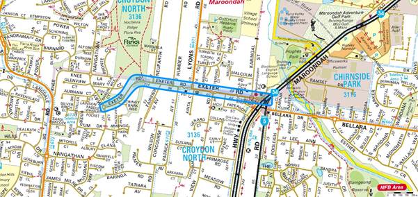
Figure 2 below shows an extract from Melways, providing
details of Exeter Road’s location, traffic calming elements and
connections to the wider road network.
|
|
|
Figure 2: Exeter Road and the wider road network
|
The section of Exeter Road between Nangathan Way and
Neuparth Road has a significant bend and crest with a steep grade heading down
to Stringybark Rise and incorporates traffic calming at the following
locations:
· a splitter island through the crest immediately west of Neuparth
Road, and
· a splitter island at Stringybark Rise.
The carriageway width of this section of Exeter Road is
approximately 7.2 metres. Parking is prohibited over the crest of the
hill between Neuparth Road and Stringybark Rise on both sides of the road,
whilst parking is only permitted on the south side of Exeter Road between
Stringybark Rise and Nangathan Way.
Figures 3 and 4 below show the bend and crest on the western
end of Exeter Road.
|
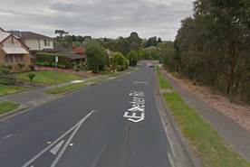
|
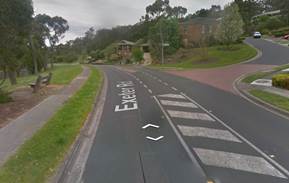
|
|
Figure 3: Exeter Road looking west
|
Figure 4: Exeter Road looking east
|
As noted above, Exeter Road provides a direct connection to
the arterial road network, Maroondah Highway, via a signalised intersection and
connects to higher order local roads, being Lyons Road and Nangathan Way, and
several lower order local roads.
Given the configuration of Exeter Road as discussed above,
in accordance with Clause 56.06 of the Maroondah Planning Scheme, Exeter Road
aligns with the road hierarchy criteria of a Connector Street – Level 2
and would therefore be expected to satisfactorily cater for in the order of
3,000 – 7,000 vehicles per day.
Council’s Engineers have previously been made aware by
local residents of their concerns relating to vehicle speeds along this section
of Exeter Road. As a result of the concerns raised by local residents,
Council’s Engineers arranged for a traffic speed and volume count of
Exeter Road immediately east of Stringybark Rise which revealed the following
results:
· The average traffic volume along Exeter Road was approximately 4,567
vehicles per day;
· The average vehicle speed was 50.4 km/h; and
· The 85th percentile speed1 was 56.5
km/h.
It should be noted that westbound direction speeds and
volumes slightly varied from the average result with the recorded speeds being
slightly higher and the volume slightly lower. It is expected that the
higher speeds are due to the downhill grade on the western approach and the
lower volume was likely a result of local residents using the western end of
Exeter Road to depart the area to avoid the traffic signals on Maroondah
Highway, and using other roads in the road network to exit / enter the local
area.
Given the above, the westbound speeds and volumes are as
follows:
· The average westbound traffic volume was approximately 2,240
vehicles per day;
· The average vehicle speed was 51.3 km/h; and
· The 85th percentile speed1 was 57.7
km/h.
Given the speeds that were recorded, particularly the in
westbound direction, Council’s Engineers developed a project scope to
install additional traffic calming in Exeter Road. The project was
subsequently included within in the Capital Works Local Area Traffic Management
(LATM) Program.
As noted above, the topography of this section of Exeter
Road results in the crest of the hill being located adjacent to Neuparth Road
and the road travelling downhill to the Nangathan Way intersection.
Whilst there is a downhill grade on this section of Exeter Road, it does
flatten on the approach to the Stringybark Rise intersection and, as such, it
has been determined that this is the most appropriate location for any new LATM
treatment with consideration to traffic engineering principles and
construction. The works proposed will involve the installation of traffic
calming treatments in Exeter Road on the eastern and western approaches to
Stringybark Rise and are expected to address the concerns with higher vehicle
speeds along this section of Exeter Road.
In regard to the petition calling on a review of the speed
limit, as noted above, this section of Exeter Road currently operates with a
50km/h speed limit. Speed signs are classed as
a Major Traffic Control Item and are under the authority and control of
VicRoads. As such any new signage or alterations to the existing speed
limit would be subject to VicRoads approval.
In accordance with the VicRoads Speed Zone Guidelines,
50km/h is the lowest operating speed permitted on an urban road unless the road
has one of the following factors:
· The road is part of a local urban area or a street where pedestrian
/ cyclist safety needs to be enhanced;
· There is a school access point on the road;
· There is a high risk remote school crossing on the road; and
· There is a high level of pedestrian activity on the road.
As none of the above operating conditions are present on
this section of Exeter Road, VicRoads would not approve lowering the speed
limit below the default urban limit of 50km/h.
With respect to the recent crash that occurred on Monday 5
September 2016, discussions with the Maroondah Highway Patrol unit of Victoria
Police indicates that the driver of the vehicle was involved in another crash
on Exeter Road just before this incident occurred and as such there may be a
link between these two crashes. The nature of the crash and road
topography suggests that driver behaviour was a factor. On this basis, it
is considered that driver behaviour was the contributing cause of the crash and
that the road geometry or operating conditions did not contribute to the crash.
Financial /
economic issues
The construction of an LATM treatment on this section of
Exeter Road has been programmed with funding from the Capital Works LATM
program budget. The LATM program has an ongoing budget allocation of $200,000,
which is sufficient for the construction of these works.
Environmental
/ amenity issues
In accordance with the guidelines of Clause 56.06 of the
Maroondah Planning Scheme, roads within the municipality are designed to
requirements based on their level within the road hierarchy.
Collector roads are designed and expected to cater for
higher traffic volumes rather than local access roads. Environmental and
amenity issues are consistent with the above hierarchical requirements.
Social / community issues
The road hierarchy determines the level of service provided
for all road users within the municipality. The road hierarchy is
important from a social perspective and is based on several factors including:
· Linkages provided with other roads in the road network.
· Linkages with commercial and residential areas within the
municipality.
· Current and future traffic volumes for roads.
· Level of transport of goods and services.
The need for roads to interconnect with other roads in the
network is vital to allow for the movement of people and goods throughout the
municipality and the state. Collector roads provide an important
connection for these movements within the municipality.
Community consultation
Local residents in the vicinity of the proposed LATM works
will be updated on the progress of the project.
Conclusion
It is considered that the crash that occurred on Exeter Road
on 5 September 2016 was a result of driver behaviour and the road condition or
geometry did not contribute to the crash.
It is recommended that Council notes the petition containing
21 signatures, and notes that additional traffic calming will be constructed in
the vicinity of the crash site as part of the Capital Works LATM program
budget, and Exeter Road does not meet the warrants set by VicRoads for a
reduced speed limit.
Attachments
Not Applicable
CONFIDENTIALITY
Not Applicable
|
RECOMMENDATION
That council
1. notes the petition containing 21
signatures
2. considers the officers report and
notes the findings of the investigation into the prayer of the petition that
ADDITIONAL traffic calming will be considered in the LATM program and that Exeter Road does not meet the
warrants for a reduced speed limit
3. Advises the hon David Hodgett MP
accordingly
|
|
DIRECTOR Planning &
Community – Phil
Turner
|
|
|
|
Planning Scheme Amendment
C97 - Heathmont Activity Centre Structure Plan
|
Item 1
|
Purpose
The purpose of this report is to consider submissions
received following exhibition of Planning Scheme Amendment C97 Heathmont
Activity Centre Structure Plan and to resolve to request the Minister for
Planning to appoint an independent panel to consider submissions.
Strategic /
policy issues
The following directions contained in Maroondah 2040:
Our Future Together and the Council Plan 2013-2017 (Year 4: 2016-2017) provide
the strategic framework that underpins the purpose of this report.
Outcome Area: An attractive,
thriving and well built community.
Our Vision: In 2040, Maroondah will
be an attractive community with high quality urban form and infrastructure that
meets the needs and aspirations of all ages and abilities. A diverse range of
housing options are available and thriving activity centres provide a broad
range of facilities and services that meet community needs. The character of
local neighbourhoods continues to be maintained while also accommodating
population growth.
Key Directions 2013 – 2017:
6.1 Encourage
high quality urban design that provides for a healthy, attractive and desirable
built form.
6.3 Work
in partnership to deliver distinctive and high quality architecture through the
use of urban design guidelines and principles.
6.7 Plan
and facilitate the development of a community where everyone can live, work and
play locally.
Background
Council previously developed the Heathmont Activity Centre
Structure Plan in consultation with a range of stakeholders. At its meeting on
26 August 2013 Council resolved to:
· Note submissions received following the exhibition of the draft
Heathmont Activity Centre Structure Plan;
· Adopt the draft Heathmont Activity Centre Structure Plan subject to
the changes proposed regarding design criteria for 4 storey developments;
· Seek authorisation from the Minister for Planning to prepare and
exhibit an amendment to the Maroondah Planning Scheme that implements and
includes the Heathmont Activity Centre Structure Plan as a reference document.
Planning Scheme Amendment C97 addresses the above Council
resolutions as well as the implementation measures contained within the
Structure Plan by implementing it into the Maroondah Planning Scheme.
Purpose of the Planning Scheme Amendment
The purpose of the Amendment is to implement the Heathmont
Activity Centre Structure Plan. The Structure Plan provides the strategic
justification for the Amendment to the Maroondah Planning Scheme. It is not the
purpose of the Amendment to revisit or substantially alter the Structure Plan,
which was adopted by Council in 2013 following extensive community and
stakeholder engagement.
Planning Scheme Amendment C97 proposes the following changes
to the Maroondah Planning Scheme:
· To amend the Municipal Strategic Statement and the Local Planning
Policy Framework to incorporate the aims of the Structure Plan.
· To insert two new schedules to the General Residential Zone (GRZ2
& GRZ3).
· To insert a new schedule to the Design and Development Overlay
Schedule 8 and to delete existing Design and Development Overlay Schedule 2.
· To replace Significant Landscape Overlay Schedule 3 with Schedule 4.
· To insert a Development Plan Overlay at the ‘Uambi’
property at 22 Allens Road.
· To include the Heathmont Activity Centre Structure Plan as a
Reference Document in the Maroondah Planning Scheme.
The proposed changes to the MSS
and new clauses to the Maroondah Planning Scheme were prepared by Council
following extensive discussion with the Department of Environment, Land, Water
and Planning (DELWP).
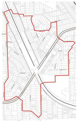
Figure 1: Area to
which Amendment C97 applies
Planning Scheme Amendment C97 applies to all
land within the Heathmont Activity Centre Structure Plan study boundary. The study area boundary is generally defined as
400 metres walking distance from the
Heathmont Railway Station, with
areas subject to land constraints such as extensive vegetation,
restrictive covenants and topography excluded. In general, the boundary follows
road reserves where possible.
Exhibition of Amendment C97
The Amendment was initially placed on public exhibition from
26 May 2016 to 1 July 2016 and was subsequently extended by a week, due to a
minor mapping error. Exhibition of the Amendment involved posting written notification
to all owners and occupiers within the Structure Plan Amendment area. A total
of 676 letters were mailed on 25 May 2016 in respect of the Amendment. Notices
were placed in the Maroondah Leader on 24 May 2016 and in the Government
Gazette on 26 May 2016.
The Amendment also featured on Council’s website and
hard copies of the Amendment documents, including the Structure Plan, were
placed on exhibition at Council’s service centres at Braeside Avenue,
Realm and the Croydon offices and library.
Issue /
discussion
Consideration of submissions
During the exhibition of Amendment C97, and the subsequent
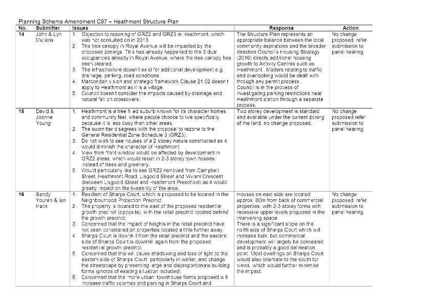
weeks, a total of 22 submissions were received. Of the submissions received:
· 2 submissions did not expressly support the Amendment, but did not
request any changes;
· 10 submissions requested changes to the Amendment;
· 10 submissions objected to the Amendment.
For ease of consideration, the issues raised in submissions
have been discussed below as follows:
· Built form and height
· Traffic and Transport
· Car parking
· Documentation of heritage
· Specific requests for changes affecting particular sites
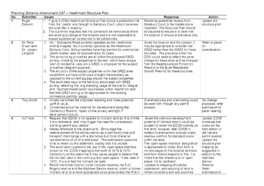
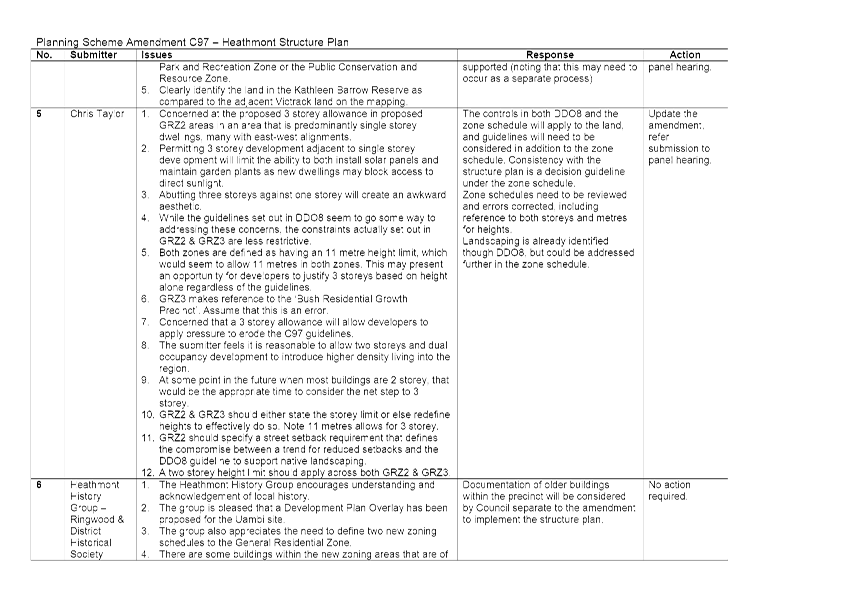
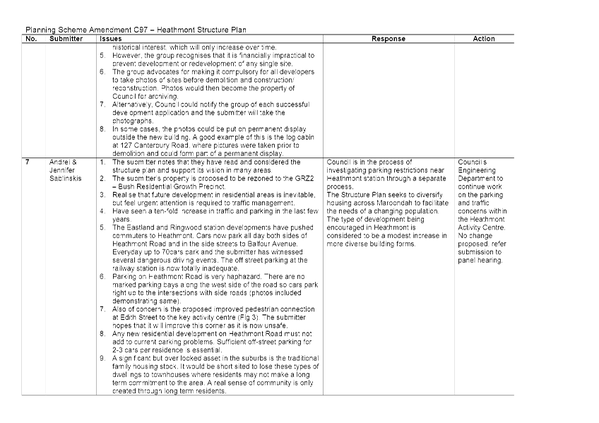
A detailed summary of submissions received can be found in Attachment
No 1.
Built form and height
Issues raised
Eight submitters raised concerns about the densities and
maximum building heights proposed under the zoning schedules. One submission
suggested a height limit of 2 storeys throughout residential zoned areas, while
another opposed two storey development in their area, submitting that the existing
single storey typologies should be maintained.
Another submitter stated that a two storey height limit
across residential areas is reasonable and that three storey development should
only be considered at a point in the future when 2 storey had become the norm.
The submission raised concerns about the aesthetic created by three storey
buildings adjacent to single storey dwellings as well as a range of amenity
issues that this might create. Specific areas referenced by submitters included
Royal Avenue, Viviani Crescent, Campbell Street and Lisgoold Street.
Another submitter raised specific concerns about amenity
issues that could be created in relation to Sharps Court. Sharps Court is
located along the boundary of the Residential Growth Precinct and the
Neighbourhood Consolidation Precinct. The submitter is concerned that 1)
overlooking and 2) overshadowing will occur on the eastern side of Sharps
Court, if buildings in the commercial spine are redeveloped to 4 storeys and
buildings on the western side of Sharps Court are redeveloped to 3 storeys, as
permitted under the proposed zoning and DDO.
Response
While the concerns of the submitters in relation to height
and density are acknowledged, the changes proposed through Amendment C97 are
considered relatively modest, especially given Heathmont’s status as a
Neighbourhood Activity Centre served by a railway station.
The Amendment should be considered in terms of the changes
that are being made to the current planning controls, as well as in the context
of the difference between what currently exists on the ground and what would be
achievable under the amendment. In many cases, 2-3 storey development would
currently be achievable, assuming the performance based standards of Rescode
can be met. There is no current mandatory maximum height limit in
Heathmont. The Rescode standards that protect residential amenity will continue
to apply, so overshadowing and overlooking will continue to be considered
through Council’s development control process.
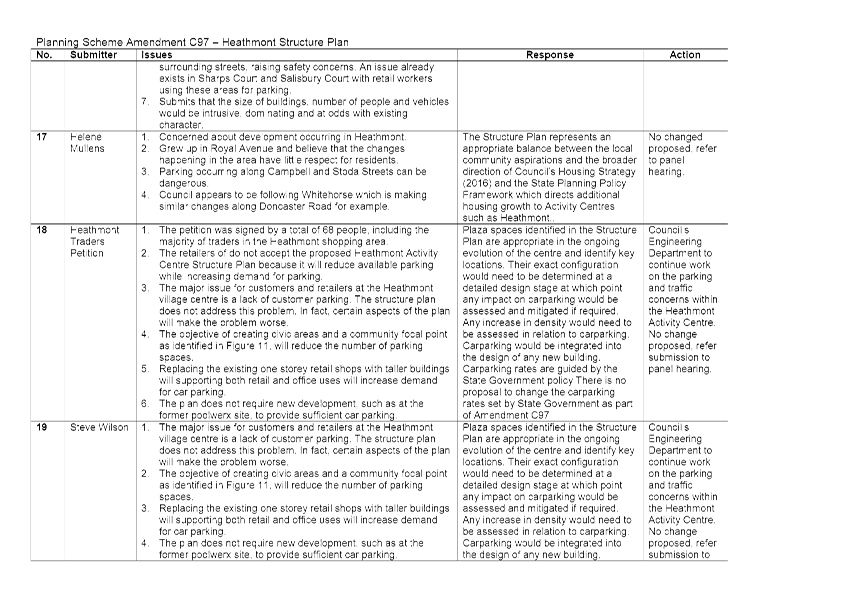
Traffic and Transport
Issues raised
Three submitters raised the issue of the current speed limit
on the Canterbury Road and its use as a freight route by a significant number
of heavy vehicles. This was a central issue for a number of submitters, who
reported safety concerns for pedestrians as well as amenity issues. Submitters
supported a reduction in the speed limit to 40km/hr.
The submission from VicRoads seeks updated wording in the
Structure Plan in relation to the bicycle network. The submission requests that
Action 4 on the implementation table in the Structure Plan be amended to use
the term ‘bicycle facilities’ rather than ‘bicycle
lanes’. The request is made on the basis that that the term
‘bicycle lanes’ raises the expectation in the community that this
is the safest and best facility for cyclists, whereas in fact an alternative
may be preferable.
In relation to the railway station, one submitter voiced
support of the demolition and redevelopment of a new station that would better
serve the needs of the community.
Response
The Heathmont Structure Plan seeks to expand sustainable
transport options in the form of cycling and pedestrian connections to provide
improved access to the railway station and commercial strip. This involves
interactions and potential conflicts between traffic, cyclists and pedestrians,
as well as the potential for bicycle lanes.
The Structure Plan includes an objective (Implementation
Table, Item 2) to initiate talks with VicRoads about the possibility of
introducing variable speed limit options for the Canterbury Road, including
reducing the limit to 40km/hr during peak shopping times. Submitter support for
a reduction in the speed limit is therefore a matter for the implementation of
the Structure Plan, rather than a cause to update the Amendment documentation.
The points raised by VicRoads are noted and will feed into
any future discussions. However, the implementation measures in the Structure
Plan are intended to provide a basis to commence discussions and investigations
and are not designed to pre-empt a detailed investigation. Other measures may
ultimately be recommended following a feasibility analysis. It is therefore not
proposed to update the Structure Plan, which was adopted by Council in 2013.
The redevelopment of the railway station is an objective of
the Structure Plan. However, it should be noted that this will largely involve
an advocacy role for Council as the station is owned by VicTrack.
Car parking
Issues raised
A number of the submissions received related primarily to
issues associated with car parking. A petition was also received from the
traders along the Canterbury Road Strip.
Petition – parking
A petition was submitted to Council on behalf of the traders
along the Canterbury Road commercial strip. A total of 68 people signed the
petition including a majority of the traders. The petition opposes the
Structure Plan on the basis that the objective of creating civic areas and a
community focal point, as identified in Figure 11 of the Structure Plan (shown
as ‘urban plazas’), would reduce car parking availability along the
commercial strip. At the same time, any intensification of commercial uses
along the retail strip will create a greater requirement for parking. The
petition also submits that the plan does not require new development to provide
sufficient additional parking.
Individual submissions – parking
A number of the individual submissions received related
largely to car parking. Submitters expressed particular concern about the
proliferation of on-street parking around the train station. The submissions
state that the park and ride area at the train station fills up early in the
morning and commuters then park cars along Heathmont Road, Campbell Street,
Stoda Street and the adjoining streets. This has given rise to both
inconvenience and safety concerns.
A number of the submitters were further concerned about the
impact that any increase in residential development is likely to have on the
availability of parking. While there was some concern about parking in the
commercial strip in the individual submissions, concerns primarily focused on
parking along residential streets near the train station.
Response
The plaza spaces identified in the Structure Plan are
appropriate in the ongoing evolution of the centre and identify key locations.
Their exact configuration would need to be determined at a detailed design
stage at which point any impact on car parking could be assessed and mitigated
if required.
While the concerns of the traders in the relation to car
parking in the commercial strip are noted, it should also be recognised that
the ‘urban plazas’ shown in the Structure Plan do not form a part
of the Design and Development Overlay (DDO) Schedule 8. While the urban plazas are
shown in the Structure Plan, these are proposals, rather than firm development
projects and have not undergone a detailed feasibility analysis and do not have
specific funding allocated. Any proposal to develop the urban plazas as shown
would involve detailed planning and consultation, should Council wish to pursue
these options.
Any increase in density would need to be assessed in
relation to car parking provided. While
the location within an activity centre anchored by a railway
station would generally reduce need for car parking, it would be anticipated
that parking would be integrated into the design of any new building. There is
no proposal through the Structure Plan to reduce existing requirements.
It is also noted that the Structure Plan (page 24) states as
follows in relation to car parking:
Retain existing on-street car
parking within the Canterbury Road commercial strip. However, in the longer
term critically review the need to provide any additional car spaces within the
centre, including investigating options to establish a stand-alone multi-deck
car park on the edge of the commercial strip.
The Structure Plan also states (page 23) that it is an
objective:
To ensure the Heathmont NAC
maintains an adequate supply of appropriately located, designed and managed on
and off-street multipurpose car parking.
As demonstrated above, one of the overarching objectives of
the Structure Plan is to ensure that an adequate supply of car parking is
maintained in the Heathmont Neighbourhood Activity Centre (NAC). The proposals
in the Structure Plan should be considered in that context.
Response – Individual submissions
Individual submissions primarily raised concerns relating to
increases in traffic volume and on-street parking. The level of on-street car
parking resulting from overflow from the train station car park was a key
concern. While the submitters concerns are acknowledged, the issue of
commuter generated, all day on-street car parking around the train station in
places such as Campbell Street and Heathmont Road is largely a parking
management issue rather than an issue that can be addressed through the
Amendment.
As such, Council’s Engineering Services Department are
investigating options in regard to parking in and around the centre.
In terms of traffic generation from new development, any
residential development activity will generate additional traffic in the
surrounding area, regardless of the location. However, an increase in
residential densities within activity centres is designed to facilitate a wider
range of options for transport, other than the use of the private car. One of
the fundamental premises of the Structure Plan is that people living within the
study area will be able to walk or cycle to the train station. It is therefore
considered that an increase in residential densities at this location will
result in a smaller impact on the overall road network, as more people will be
able to walk or cycle to their destination.
Documentation of heritage
Issues raised
The Heathmont History Group suggested that a requirement be
put in place that a photographic record must be made of buildings prior to
demolition, or that history group is notified before a demolition takes place
so that they can take pictures. A photographic record of the area could thereby
be built up for future generations.
Response
While this is an idea worthy of consideration, it is outside
the scope of the Amendment and should be considered in formulating
Council’s strategic approach to heritage preservation and
protection.
Specific requests for changes affecting particular sites
Issues raised
The submission summaries in the attachments to this report
provide a detailed overview of the matters raised in each individual
submission. A number of those submitters made specific requests for the
boundaries of the zoning precincts and proposed zoning to be amended. These are
outlined briefly below:
202-210 Canterbury Road
The submitter is seeking the rezoning of 202-210 Canterbury
Road to the Commercial 1 Zone, given the prominent location of the site along
Canterbury Road and existing commercial uses.
Response - 202-210 Canterbury Road
The proposal would represent a significant departure from
the strategy set out in the Structure Plan, on which Amendment C97 is based. It
is therefore considered to be outside of the scope of the current amendment and
could instead be the subject of a subsequent proponent led planning scheme
amendment process. It is however considered that commercial zoning at this
location would be inappropriate as it would add an additional commercial axis
and dilute the commercial area. However, alternatives to townhouses could be
explored through a separate process.
196 Canterbury Road
The proprietor at 196 Canterbury Road (Barclays) objects to
the suggestion in the Structure Plan for a café/ restaurant at the
railway station.
Response - 196 Canterbury Road
A café or restaurant could be provided at the station
based on current planning controls. Future uses at the station would be
determined by Public Transport Victoria as part of any future redevelopment of
any station facilities. There is no indication that this is likely to occur any
time in the near future and no changes are proposed.
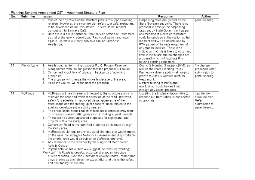
VicTrack submission
Seeks removal of the proposed Design and Development Overlay
DDO8 from VicTrack land. Also requests the removal of reference to the
‘open space interface’ to the north of 127b & 127C Canterbury
Road.
Response - VicTrack submission
While there may be a need to alter the DDO to include
exemptions that avoid overly onerous controls for standard works on the rail
line and train station, there is no rationale for its complete deletion. Given
the unknown development potential of VicTrack land it is considered prudent to
retain the DDO controls on that land. The ‘open space interface’
designation is appropriate to retain. Built form is not envisaged in this
location and new built form should respond to this.
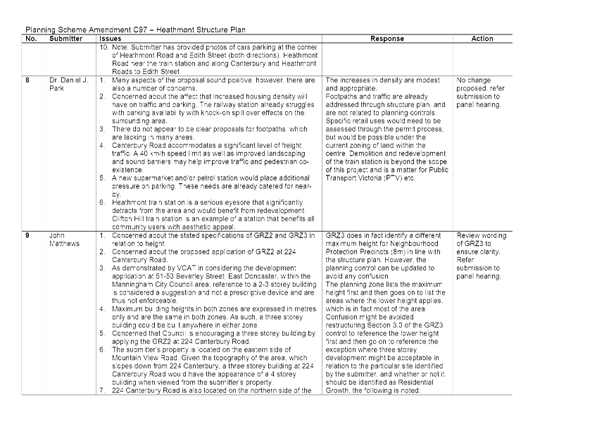
1&3 Dickasons Road
The landowners have requested that GRZ2 be applied to
1&3 Dickasons Road, instead of GRZ3 as currently proposed.
Response - 1&3 Dickasons Road
Given the location, context and use of these properties, it
is appropriate to consider the GRZ2 rather than the GRZ3. This issue will be
examined further through the panel process.
3 Edith Street
The landowner at 3 Edith Street has requested that the
property is zoned GRZ2 rather than GRZ3 as proposed.
Response - 3 Edith Street
There is a notable difference between the
‘backstreets’ and the Heathmont Road fronting the railway in terms
of the streetscape character which has underpinned the identification of these
areas. The Amendment facilitates a stepping down of development from the
Heathmont Road (GRZ2), through Edith Street (GRZ3) and on towards the
properties on Balfour Avenue, which are in the Neighbourhood Residential Zone
(western side). As such, the proposed controls are considered appropriate and
it is recommended that they should remain as they are.
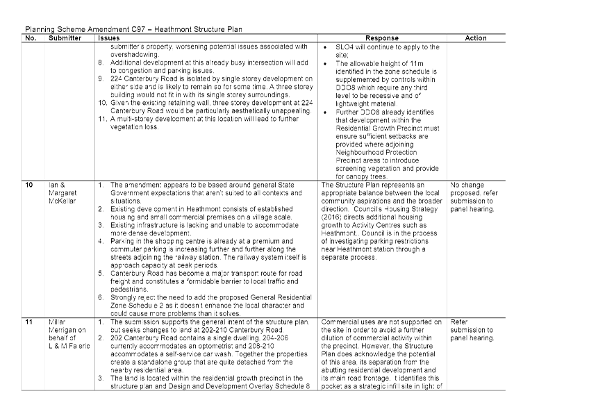
Salisbury Court/ Uambi site
The landowner requests that pedestrian access across the submitters
property from the Uambi site to Salisbury Court is removed.
Response - Salisbury Court/ Uambi site
It is considered appropriate to undertake a minor update to
the Structure Plan to clarify that the location shown for the pedestrian link
is indicative and does not necessarily need to traverse the submitters
property.
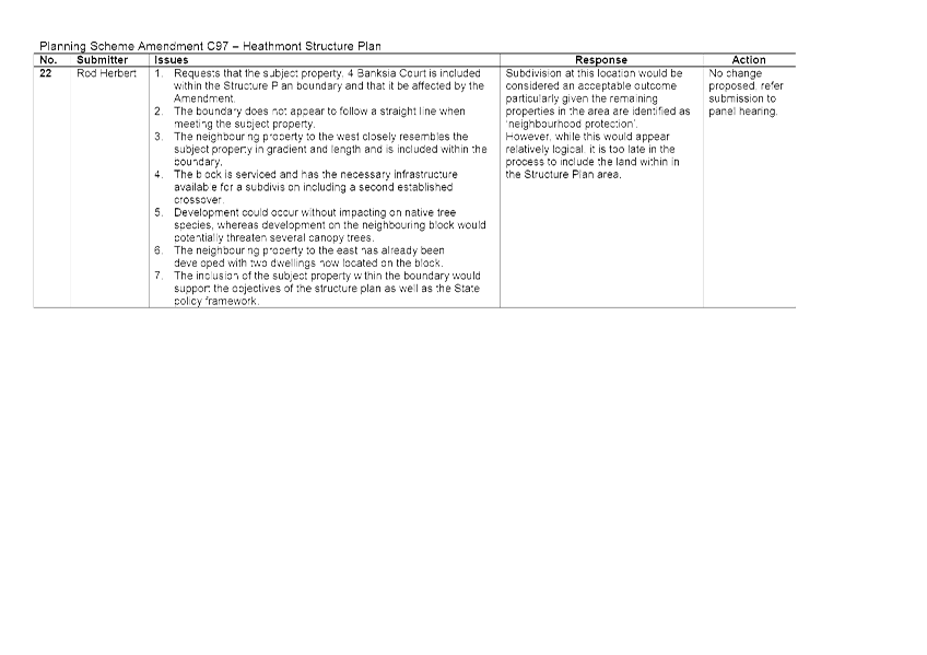
4 Banksia Court
The landowner has requested that 4 Banksia Court is included
in the amendment (rezoned from NRZ2 to GRZ3).
Response - 4 Banksia Court
While there is merit in the inclusion of the submitters
property in the GRZ3 area based on local conditions and the existing pattern of
development, the current amendment is based on the Structure Plan, which does
not include the subject site. Any change to the proposed planning controls
would therefore need to be pursued by way of a separate amendment.
Overall Recommendations
In response to the submissions received, it is suggested
that the following changes are recommended to the Panel hearing:
Structure of Zoning & Design and Development Overlay
Controls
A number of submitters have raised concerns about the
controls set out under the zoning schedules, particularly in relation to
height. Other submitters have found the manner in which the zoning schedules
relate to the Design and Development Overlay confusing. While the zoning
schedules set out maximum heights, as well as other measures such as reduced
setbacks, the proposed Design and Development Overlay (DDO8) applies strict
design criteria that must be met in order to qualify. However, it is clear from
the submissions that residents have focused on the proposed zoning schedules
rather than the DDO. A reading of the zoning schedules alone could lead the
reader to understand that the controls in the zoning schedule are achievable in
all circumstances, which is not the case. It is therefore proposed to remove
the controls from the proposed zones and instead rely solely on the Design and
Development Overlay (DDO). This will not result in a change to the outcome
achievable on a given site, but rather is intended to make the proposed
controls easier to understand. This approach would be submitted to the Panel
for its consideration.
Renaming of ‘Growth’ Precincts
The Structure Plan was prepared in 2012, before the new
residential zones were brought into effect in Maroondah in 2014. The use of the
term ‘growth precinct’ may therefore cause confusion, as people
associate the term with the ‘Residential Growth Zone’ which allows
for higher density development. It is recommended that the names of the
‘growth precincts’ are changed to avoid confusion.
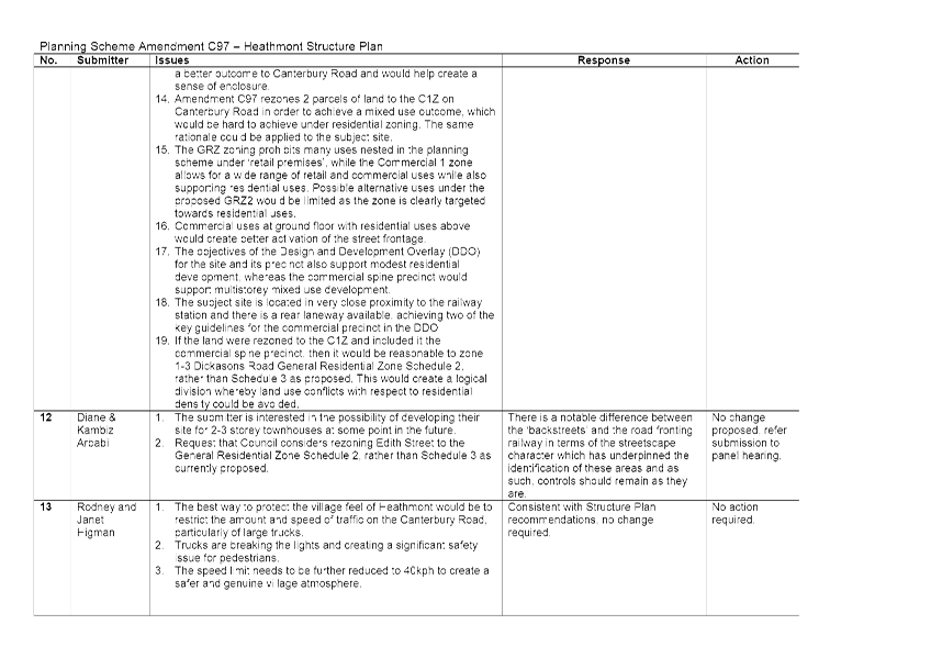
Submitter Register
A number of additional minor changes are proposed in
response to submissions. Please see the attached detailed submitter register
for details.
Financial /
economic issues
The costs associated with the preparation and
implementation of the Amendment will be met through the existing Council
budget.
Environmental
/ amenity issues
Environmental and amenity issues were carefully considered during the preparation
of the structure plan, upon which the current planning scheme amendments are
based. The Significant Landscape Overlay will continue to apply in all
residential areas.
Social /
community issues
The Structure Plan provides a detailed profile of the community
that lives, works and utilises the Heathmont activity centre. A range of issues were identified that impact
on the liveability and functioning of the centre, which the Structure Plan seeks to address
through ongoing implementation.
These cover subjects including social connectedness, access and
movement, the local economy and future aspirations for built form
and the natural environment.
Community consultation
The Amendment was exhibited in accordance with Section 19 of
the Planning and Environment Act 1987. The Amendment was placed on public
exhibition from 26 May 2016 to 1 July 2016 and subsequently extended until 8
July due to a minor mapping error that was identified shortly after the
Amendment commenced exhibition. A total of 22 submissions were received
including 1 petition.
The preparation of the Structure Plan itself benefited from extensive community consultation canvassing ideas across a broad range of subject matter and ideas.
Council was guided by Community Reference and Steering Groups throughout the preparation of the Structure
Plan.
Conclusion
Council previously prepared and adopted a Structure Plan for
the Heathmont Activity Centre. Planning Scheme Amendments C97 has been prepared
in response to a specific implementation measure in the adopted Structure Plan
to implement the land use planning recommendations of the Structure Plan into
the Maroondah Planning Scheme.
Public exhibition of the Amendment ran from 26 May 2016 to 1
July 2016 and was subsequently extended until 8 July. Since exhibition commenced,
a total of 22 written submissions have been received, including a number of
late submissions. The submissions covered a broad range of issues, from
residential density and maximum buildings heights, to requested amendments to
the proposed zoning of specific sites.
As some of the issues raised in the submissions received
cannot be addressed, it is considered appropriate to request the Minister for
Planning to appoint an independent panel.
Attachments
|
1.⇩
|
Detailed
summary of submissions for Council Report Amendment C97
|
CONFIDENTIALITY
Not Applicable
|
RECOMMENDATION
That council
1. requests the minister for
planning to appoint an independent panel to consider submissions received
2. informs submitters that an
independent panel is to be appointed
3. NOTE OFFICER RECOMMENDATIONS in
the attached submitter register and RELATING TO tHE Structure of Zoning &
Design and Development Overlay Controls AND the Renaming
of ‘Growth’ Precincts
|
|
ATTACHMENT No: 1 - Detailed summary of submissions for Council Report Amendment C97
|
|
Item 1
|
|
DIRECTOR Planning & Community – Phil Turner
|
|
|
|
Planning Scheme Amendment
C96 - Ringwood East Activity Centre Structure Plan
|
Item 2
|
Purpose
The purpose of this report is to consider submissions
received following exhibition of Planning Scheme Amendment C96 Ringwood East
Activity Centre Structure Plan and to resolve to request the Minister for
Planning to appoint an independent panel to consider submissions.
Strategic /
policy issues
The following directions contained in Maroondah 2040:
Our Future Together and the Council Plan 2013-2017 (Year 4: 2016-2017) provide
the strategic framework that underpins the purpose of this report.
Outcome Area: An attractive, thriving
and well built community.
Our Vision: In 2040, Maroondah will
be an attractive community with high quality urban form and infrastructure that
meets the needs and aspirations of all ages and abilities. A diverse range of
housing options are available and thriving activity centres provide a broad
range of facilities and services that meet community needs. The character of
local neighbourhoods continues to be maintained while also accommodating
population growth.
Key Directions 2013 – 2017:
6.1 Encourage
high quality urban design that provides for a healthy, attractive and desirable
built form.
6.3 Work
in partnership to deliver distinctive and high quality architecture through the
use of urban design guidelines and principles.
6.7 Plan
and facilitate the development of a community where everyone can live, work and
play locally.
Background
Council previously developed the Ringwood East Activity
Structure Plan in consultation with a range of stakeholders. At its meeting on
26 August 2013 Council resolved to:
· Note submissions received following the exhibition of the draft
Ringwood East Activity Centre Structure Plan.
· Adopt the draft Ringwood East Activity Centre Structure Plan as
exhibited.
· Seek authorisation from the Minister for Planning to prepare and
exhibit an amendment to the Maroondah Planning Scheme that implements and
includes the Ringwood East Activity Centre Structure Plan as a reference
document.
Planning Scheme Amendment C96 addresses Council’s
resolutions as well as the implementation measures contained within the
Structure Plan by implementing it into the Maroondah Planning Scheme.
Purpose of the Planning Scheme Amendment
The purpose of the Amendment is to implement the Ringwood
East Activity Centre Structure Plan. The Structure Plan provides the strategic
justification for the Amendment to the Maroondah Planning Scheme. It is not the
purpose of the Amendment to revisit or substantially alter the Structure Plan,
which was adopted by Council in 2013 following extensive community and stakeholder
engagement.
Planning Scheme Amendment C96 proposes the following changes
to the Maroondah Planning Scheme:
· To amend the Municipal Strategic Statement (MSS) and the Local
Planning Policy Framework to incorporate the aims of the Structure Plan.
· To insert two new schedules to the General Residential Zone (GRZ2
& GRZ3).
· To insert a new schedule to the Design and Development Overlay
(DDO6).
· To include the Ringwood East Activity Centre Structure Plan as a
Reference Document in the Maroondah Planning Scheme.
The proposed changes to the MSS and new clauses to the
Maroondah Planning Scheme were prepared by Council following extensive
discussion with the Department of Environment, Land, Water and Planning (DELWP)
over a period of months.
The Amendment area corresponds to the Ringwood East Activity
Centre Structure Plan boundary, which is defined by Mt Dandenong Road and
Eastfield Road to the north, Federal Road and Illoura Avenue to the west and
Knaith Road and Tween Street to the south. The eastern boundary is defined by
Short Street and the rear boundaries on the east side of Victoria Street.
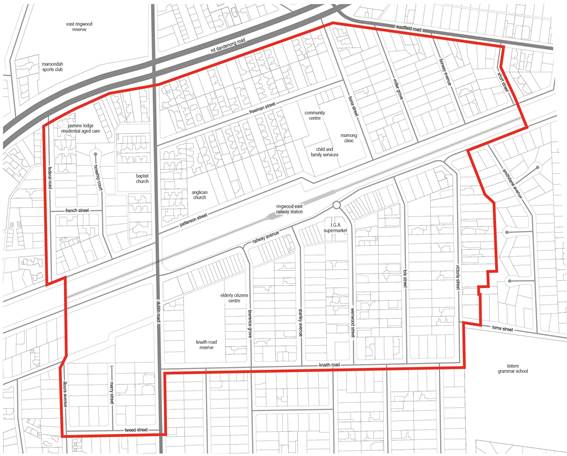
Figure 1: Area to which
Amendment C96 applies
Exhibition of Amendment C96
Planning Scheme Amendment C96 was placed on public
exhibition from 26 May 2016 to 1 July, 2016. Exhibition of the Amendment
involved written notification to all owners and occupiers within the Amendment
area. A total of 1,095 letters were mailed on 25 May 2016 in respect of
Amendment C96. Notices were placed in the Maroondah Leader on 24 May 2016 and
in the Government Gazette on 26 May 2016.
The Amendment also featured on Council’s website and
hard copies of the Amendment documents, including the Structure Plan, were
placed on exhibition at Council’s service centres at Braeside Avenue,
Realm and the Croydon offices and library.
Issue /
discussion
Consideration of submissions
During the exhibition of Amendment C96, and the subsequent
weeks a total of 19 submissions were received. Of the submissions received:
· 3 submissions supported the Amendment as exhibited;
· 3 submissions did not expressly support the Amendment, but did not
request any changes;
· 7 submissions requested changes to the Amendment;
· 6 submissions objected to the Amendment.
The issues raised in submissions can be summarised as
follows:
· Built form and height
· Transport and parking
· Environment and sustainability
· Specific requests for changes to particular sites
A detailed summary of all submissions
received and a written response can be found in Attachment No 1.
Built form and height
Issues raised
Seven submitters raised concerns about the proposed three
storey maximum height limit in some residential areas. Another submitter was
concerned in particular about the possibility of 2-3 storey development around
the Knaith Road reserve and felt that this would negatively impact the amenity
of the reserve.
Three submitters raised the issue of height and density in
the Lois Street – Victoria Street area, questioning the inclusion of the area
in the ‘Residential Growth Precinct’ and Residential Growth:
Strategic Precinct. One submitter was particularly concerned that the growth
precinct not extend so far down Victoria Street.
The 1-2 storey height limits to the south of the study area
were generally well supported by residents. Submitters in this area generally
accepted the prospect of increased development just to the south of the
commercial area, but did not wish to see it encroach any further into the
protection precinct.
The mandatory nature of the height controls was opposed by a
submitter who asserted that taller buildings should be considered on their
merits and that proposals that exceed the proposed heights should be tested
through the development application process. The submitter questioned whether
there was a basis in the Structure Plan for applying mandatory height controls.
A submission was received on behalf of EACH, who operate a
range of community services from their site on Patterson Street/ Freeman
Street. Their concern was that the maximum height limit specified in the
amendment would not facilitate the proposed expansion of services, as a portion
of the EACH site is within residential zoning.
Response
The proposed three storey height limit in a number of
precincts is designed to facilitate a modest increase in housing densities in
the area. Apart from the commercial spine and the sites designated as key
infill development sites, apartment forms aren’t supported by the
Structure Plan or the Amendment. The form of development supported by Amendment
C96 in locations where three storeys is supported, is limited to townhouses and
duplexes.
A three storey townhouse can typically have a smaller
footprint than a two storey version, which allows for more space for landscaping
and the planting of canopy trees. The three storey allowance also allows for
the construction of duplex development, whereby a walk up unit can be provided
on the ground floor with a two storey dwelling above. This allows for the
construction of ground floor dwellings that can suit an ageing population by
providing walk-up units within proximity to the range of services available in
the activity centre.
While Rescode currently provides standards for heights
within residential zones, the standards are not mandatory controls and can be
exceeded if the associated objective is met. The Amendment proposes zoning
schedules that include mandatory height limits which dwellings are not
permitted to exceed in the residential areas. Mandatory maximum height controls
are considered appropriate to provide certainty to the community into the
future.
The proposed Design and Development Overlay provides
guidance on the form that townhouse developments should take, requiring
setbacks to create recessive, less visually intrusive elements. The Amendment
also provides guidance on visual appearance in terms of materials to minimise
visual impact.
In response to the EACH submission, it is recommended that
the Amendment documents are updated to clarify that mandatory height controls
should not apply to non-residential development, such as community facilities
which are located within residential zones.
Some submitter concerns were raised in relation to the
application of the Residential Growth Precinct and the corresponding GRZ2
zoning, specifically between Lois Street and Victoria Street. Accordingly
a reduction in maximum heights is considered appropriate given the existing
scale and nature of development on Victoria Street (ie from 3 storey to 2
storey).
Transport and Parking
Issues raised
Several submitters were concerned about the impact that an
increase in residential densities may have on the availability of parking.
While there was some concern about parking in the commercial strip, it
primarily focused on parking along residential streets both north and south of
the railway line. One submitter questioned whether the residential growth
precinct located behind the commercial strip was too extensive. Others were
concerned about overflow parking from new dwellings if sufficient parking was
not accommodated onsite.
One submitter wrote to oppose the proposed vehicular link
shown across the Australian Defence Force (ADF) site, connecting Nicholson
Street to the Dublin Road. While there is currently no indication that the site
will be redeveloped, the submitter was concerned about increases in traffic
volumes on Nicholson Street if the connection was ever constructed.
Response
The Maroondah Planning Scheme sets out the requirements for
parking in new development. Parking standards are set out under Clause 52.06 of
the Particular Provisions and require new development to provide parking for
each dwelling, with the number of parking spaces related to the size of the
dwelling. Any variation from the standards would require approval through the
development application process.
Issues associated with on street parking would need to be
addressed through parking restrictions and permitting and are beyond the remit
of the Amendment. A number of residential streets throughout the study area
already have parking restrictions. It is noted that pedestrian improvements are
proposed.
Council’s Engineering Services Department are
investigating options in regard to parking in and around the Centre.
Concerning traffic generation from new development, any
residential development activity will generate additional traffic in the
surrounding area, regardless of the location. However, an increase in
residential densities within activity centres is designed to facilitate a wider
range of options for transport, other than the use of the private car. One of
the fundamental premises of the Structure Plan is that people living within the
study area will be able to walk or cycle to the train station. It is therefore
considered that an increase in residential densities at this location will
result in a smaller impact on the overall road network, as more people will be
able to walk or cycle to their destination.
In terms of the proposed Dublin Road to Nicholson Street
connection across the ADF site, Council is not aware of any plans by the ADF to
vacate the site, so the issue is not likely to eventuate for some time. Any
future development of the ADF site will need to be assessed on the basis of the
full proposal when it was prepared. As part of such a proposal, a vehicular
connection would provide a clear delineation of spaces. Given the surrounding
road network it is considered unlikely to result in significant through traffic
to the west and could be designed to avoid impacts. As a principle for the
development of this site this connection should remain.
Environment and Sustainability
Issues raised
A submission was received from Transition Towns Maroondah
(TTM) that focused largely on environmental and sustainability matters. The
submission covers a range of environmental issues, from seeking additional
references to climate change in the Structure Plan to the dangers posed by
extremes of weather, such as bushfires and floods, to issues such as food
security. The submission voices support for a number of areas of the Amendment,
while seeking changes in others.
Response
Many of the comments raised by TTM relate to the text of the
Structure Plan itself, which was adopted by Council in 2013 following a robust
community engagement process. It is not proposed to update the Structure Plan
through the amendment process. The TTM submission has therefore been considered
primarily in the context of the proposed amendment documentation.
In terms of the points raised concerning climate change, the
Structure Plan forms part of a wider strategy, echoed in the recently adopted
Maroondah Housing Strategy, to direct a greater proportion of Maroondah’s
development into Activity Centres. The Structure Plans relates to an
approximately 400 metre area around the train stations, or what is considered
walking distance. Directing a greater proportion of Maroondah’s
development into areas where people can walk or cycle to public transport
facilities as well as shops, cafes, and other amenities, reduces reliance on the
use of private cars and leads to a reduction in carbon emissions. While people
are likely to continue to own private vehicles, any reduction in their day to
day usage, whether as a result of driving shorter distances or of walking or
cycling instead, reduces carbon emissions.
A more detailed response to the TTM submission is contained
in Attachment No 1.
Specific requests for changes to
Particular Sites
Issues raised
The submission summaries in the attachments to this report
provide a detailed overview of the matters raised in each individual
submission. A number of those submitters made specific requests for changes to
the Amendment. These are outlined briefly below:
8-12 Lois Street, Ringwood East
The submitter requests the inclusion of 8-12 Lois Street in
the Residential Growth Precinct and GRZ2 instead of the Residential
Protection Precinct and GRZ3.
Response - 8-12 Lois Street, Ringwood East
While the proposal which would involve the integrated
redevelopment of a group of four lots may have merit, the change requested
represents a significant departure from the approach set out in the Structure
Plan, on which the Amendment C96 is based. It is therefore considered to be
outside of the scope of the Amendment and could instead be the subject of a subsequent
proponent led planning scheme amendment process. This would involve
notification of neighbours in the area.
VicTrack land
The submission received
from VicTrack related to the railway station and associated land affected by
the proposed Design and Development Overlay (DDO). No changes to the zoning of
VicTrack land are proposed. VicTrack have requested that the proposed DDO is
not applied to their land. The submission is detailed in Appendix A.
Response - VicTrack
land
While there may be a need to alter the DDO to include
exemptions that avoid overly onerous controls for standard works on the rail
line and train station, there is little rationale for its complete deletion.
Built form controls are still relevant to the land as new built form is contemplated
in the south western carpark in the Structure Plan.
Overall Recommendations
In response to the submissions received, it is suggested
that the following changes are recommended to the Panel hearing:
Structure of Zoning & Design and Development Overlay
Controls
A number of submitters have raised concerns about the
controls set out under the zoning schedules, particularly in relation to
height. Other submitters have found the manner in which the zoning schedules
relate to the Design and Development Overlay confusing. While the zoning
schedules set out maximum heights, as well as other measures such as reduced
setbacks, the proposed Design and Development Overlay (DDO6) applies strict
design criteria that must be met in order to qualify. However, it is clear from
the submissions that residents have focused on the proposed zoning schedules
rather than the DDO. A reading of the zoning schedules alone could lead the
reader to understand that the controls in the zoning schedule are achievable in
all circumstances, which is not the case. It is therefore proposed to remove
the controls from the proposed zones and instead rely solely on the Design and
Development Overlay (DDO). This will not result in a change to the outcome
achievable on a given site, but rather is intended to make the proposed
controls easier to understand. This approach would be submitted to the Panel
for its consideration.
Proposed heights on Victoria Street
Given the submissions received from residents and the
concerns expressed about heights in the Lois Street – Victoria Street
area, it is considered appropriate to make a recommendation to the Panel that a
maximum height limit of two storeys apply along Victoria Street, rather than a
maximum of three storeys as proposed. This change is considered appropriate
given the existing nature and scale of development on that street. The change
would require an update to the proposed zoning schedule and Design and
Development Overlay (DDO6).
Renaming of ‘Growth’ Precincts
The Structure Plan was prepared in 2012, before the new
residential zones were brought into effect in Maroondah in 2014. The use of the
term ‘growth precinct’ may therefore cause confusion, as people
associate the term with the ‘Residential Growth Zone’ which allows
for higher density development. It is recommended that the names of the
‘growth precincts’ are changed to avoid confusion.
Submitter Register
A number of additional minor changes are proposed in
response to submissions. Please see the attached detailed submitter register
for details.
Financial /
economic issues
The costs associated with the preparation and
implementation of the Amendment will be met through the existing Council
budget.
Environmental
/ amenity issues
Environmental and amenity issues were carefully considered during the preparation
of the Structure Plan, upon which the current planning scheme amendments are
based. The Significant Landscape Overlay will continue to apply in all
residential areas.
Social /
community issues
The
Structure Plan provides a detailed
profile of the community that lives, works and utilises the
Ringwood East Activity Centre. A range of issues were identified that impact on
the liveability and functioning of the centre, which the Structure Plan seeks to address
through ongoing implementation.
These cover subjects including social connectedness, access and
movement, the local economy and future aspirations for built form
and the natural environment.
Community consultation
The Amendment was exhibited in accordance with Section 19 of
the Planning and Environment Act 1987. It was placed on public exhibition from
26 May 2016 to 1 July 2016. A total of 19 submissions were received. The preparation
of the Structure Plan itself benefited
from extensive community consultation canvassing ideas across a broad range of subject matter and ideas.
The preparation of the Structure Plan itself benefited from extensive community consultation canvassing ideas across a broad range of subject matter and ideas.
Council was guided by Community Reference and Steering Groups throughout the preparation of the structure
plan.
Conclusion
Council previously prepared and adopted a Structure Plan for
the Ringwood East Activity Centre. Planning Scheme Amendments C96 has been
prepared in response to a specific implementation measure in the adopted
Structure Plan to implement the recommendations of the Structure Plan into the
Maroondah Planning Scheme.
Public exhibition of Amendment C96 ran from 26 May 2016 to 1
July 2016. Since exhibition commenced, a total of 19 written submissions have
been received. The submissions covered a broad range of issues, from
residential density and maximum buildings heights, to requested amendments to
the proposed zoning of specific sites, to environmental, sustainability and heritage
issues.
As some of the issues raised in the submissions received
cannot be addressed, it is considered appropriate to request the Minister for
Planning to appoint an independent panel.
Attachments
|
1.⇩
|
Detailed
summary of submissions for Council Report Amendment C96
|
CONFIDENTIALITY
Not Applicable
|
RECOMMENDATION
That council
1. requests the minister for
planning to appoint an independent panel to consider submissions received
2. Informs submitters that an
independent panel is to be appointed
3. NOTE OFFICER RECOMMENDATIONS in
the attached submitter register and RELATING TO tHE Structure of Zoning &
Design and Development Overlay Controls, Proposed heights on Victoria Street AND Renaming of ‘Growth’
Precincts
|
|
ATTACHMENT No: 1 - Detailed summary of submissions for Council Report Amendment C96
|
|
Item 2
|
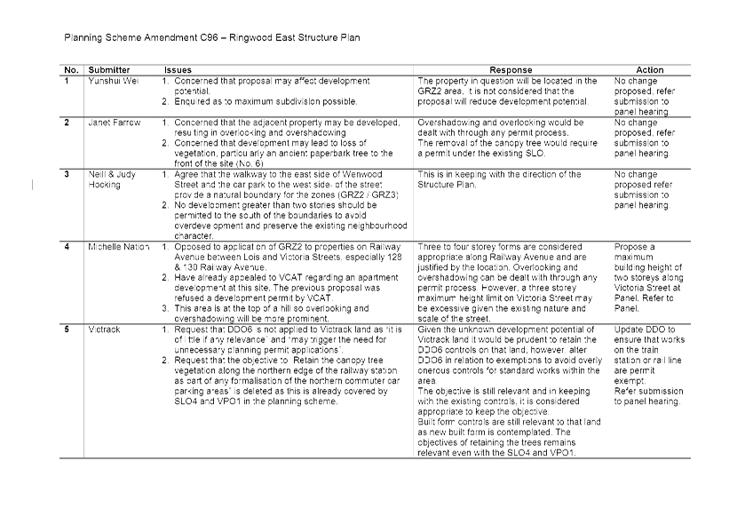
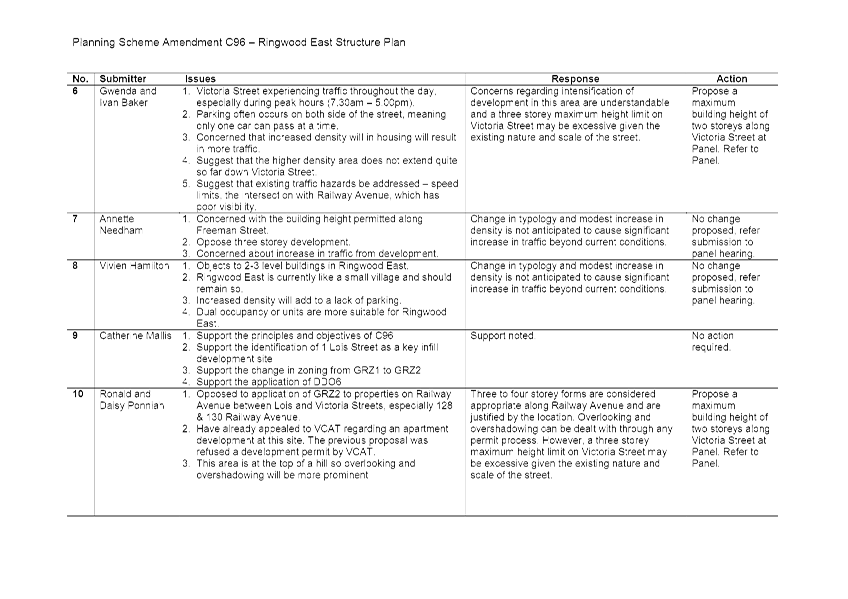

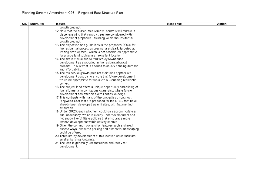
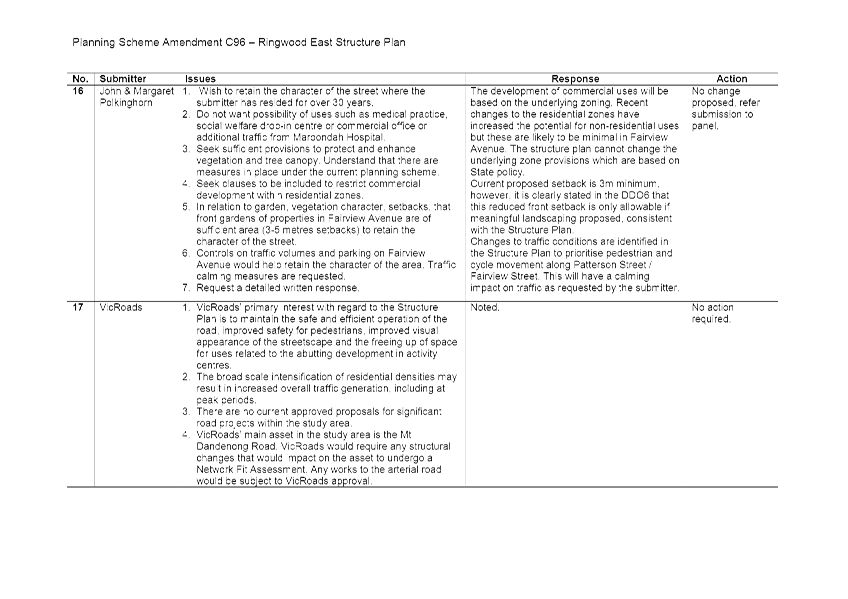
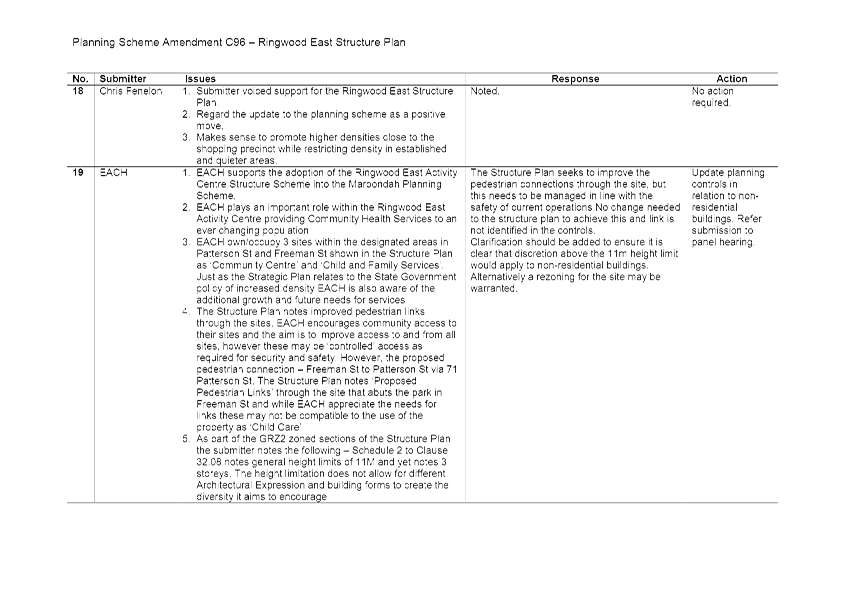
|
DIRECTOR Planning & Community – Phil Turner
|
|
|
|
Know Your Council Website -
2015/16 Local Government Performance Reporting Framework (LGPRF) Results
|
Item 3
|
Purpose
To advise that 2015/16 results from the Local Government
Performance Reporting Framework have been released to the public via the
‘Know Your Council’ website. This website compares Maroondah City
Council results to the average results from other local government areas.
Strategic /
policy issues
The following directions contained in Maroondah 2040:
Our Future Together and the Council Plan 2013-2017 (Year 4: 2016-2017) provide
the strategic framework that underpins the purpose of this report.
Outcome Area: A well governed and
empowered community
Our Vision: In 2040, Maroondah will
be an empowered community that is actively engaged in Council decision making
through processes that consider the needs and aspirations of all ages and
population groups. Council will provide strong and responsive leadership,
ensuring transparency, while working with the community to advocate for and
‘champion’ local needs.
Key Directions 2013 – 2017:
8.1 Provide enhanced governance that is transparent,
accessible, inclusive, and accountable
8.2 Ensure responsible and sustainable management of
Maroondah’s resources, assets, infrastructure, and natural environment
Priority Action 2015-2016:
Not Applicable
Background
The Victorian Government established the Local Government
Performance Reporting Framework (LGPRF) in 2014 to enable consistent
measurement and reporting of performance across a range of common areas of
service delivery. The Framework includes performance data on ten of the
services provided by Council to the local community. The Framework also
includes information on Council’s financial performance and their
sustainable capacity.
The State Government has recently released sector-wide
information from the Local Government Performance Reporting Framework for the
2015/16 financial year on the ‘Know Your Council’ website (https://www.knowyourcouncil.vic.gov.au).
This website is designed to be an accessible, easy to understand online
resource which helps the community understand how councils work, explore
information about their municipality and compare a council’s performance
to other councils.
Through this website, Maroondah City Council's performance
on Local Government Performance Reporting Framework indicators for the 2015/16
financial year can be reviewed in comparison with average scores for 'similar
councils' and the average for all Victorian councils. The site also enables
Maroondah's results to be compared directly against results for other municipalities
that are included within the same 'similar councils' group. For the purposes of
this website, the 'similar councils' group for Maroondah includes all
metropolitan councils except interface and growth area municipalities.
Issue /
discussion
Maroondah City Council’s performance is measured
against a wide range of different indicators, including those indicators within
the Local Government Performance Reporting Framework. These results were
published as part of the Maroondah City Council Annual Report 2015/16.
The 2015/16 Local Government Performance Reporting
Framework results indicates that Maroondah City Council performs relatively
well on most Local Government Performance Reporting Framework indicators in
comparison to ‘similar councils’ and ‘all councils’.
Some highlights include:
· The cost of the library service per library visit at Maroondah
libraries was $3.01, compared with $6.61 for similar councils.
· The average time taken to decide on planning applications, which was
29 days for Maroondah, compared to an average of 90.91 days for similar
councils.
· Participation in key age and stage appointments for Maternal and
Child Health services was at 90.62%, compared with 79.64% for similar councils.
· The time taken to commence delivery of home and community care
services was 12.16 days, compared to an average of more than 21 days by similar
councils.
· The proportion of waste diverted from landfill was also higher than
the average for all councils.
In recognition of these excellent results, The Mayor,
Deputy Mayor and Chief Executive Officer attended a Minister for Local
Government function in late November with the Hon. Natalie Hutchins MP,
Minister for Local Government, where Maroondah was one of just five Councils
showcased for outstanding performance. Maroondah’s performance in relation
to the cost of the library service was one of the indicators profiled at this
function.
Details on the Local Government Performance Reporting
Framework service performance results in 2015/16 can be found in the attached
document which summarises Maroondah’s performance compared with the
average for ‘similar councils’ and ‘all councils’.
Financial /
economic issues
The 2015/16 Local Government Performance Reporting Framework
comparative service performance results indicates that Maroondah performed very
well compared with ‘similar councils’. For 15 of the 19 service
cost indicators in 2015/16, Maroondah delivered the service at a lower cost
than the average for ‘similar councils’.
Environmental
/ amenity issues
Not Applicable
Social /
community issues
Not Applicable
Community
consultation
The community have been advised of the Local Government
Performance Reporting Framework results via the Maroondah City Council Annual
Report 2015/16. A link to the ‘Know Your Council’ website is
available on Council’s website.
Conclusion
Maroondah City Council results for the Local Government
Performance Reporting Framework in 2015/16 were recently released by the
Victorian Government on the ‘Know your Council’ website.
Council’s comparative performance compared with average results for
‘similar councils’ and ‘all councils’ can be found on
this website. Many excellent service performance results were achieved in
2015/16, with Council’s performance on one of these indicators recently
profiled at a Minister for Local Government function for Mayors and Chief
Executive Officers.
Attachments
|
1.⇩
|
Service
Performance Comparative Results 2015/16 - Local Government Performance
Reporting Framework
|
CONFIDENTIALITY
Not Applicable
|
RECOMMENDATION
That COUNCIL NOTE THE PUBLIC RELEASE
OF LOCAL GOVERNMENT PERFORMANCE REPORTING FRAMEWORK INDICATOR RESULTS FOR
2015/16 THROUGH THE KNOW YOUR COUNCIL WEBSITE
|
|
ATTACHMENT No: 1 - Service Performance Comparative Results 2015/16 - Local Government
Performance Reporting Framework
|
|
Item 3
|
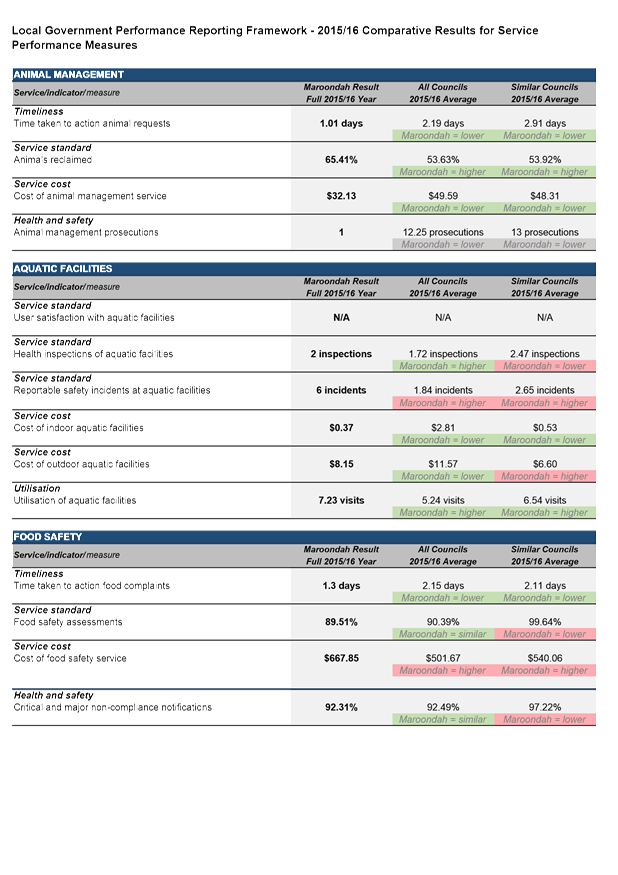
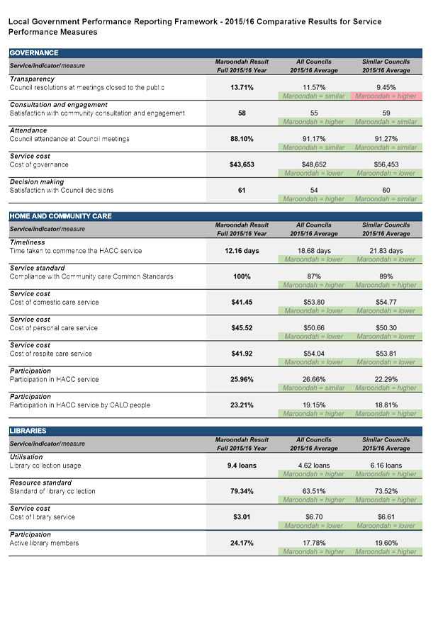
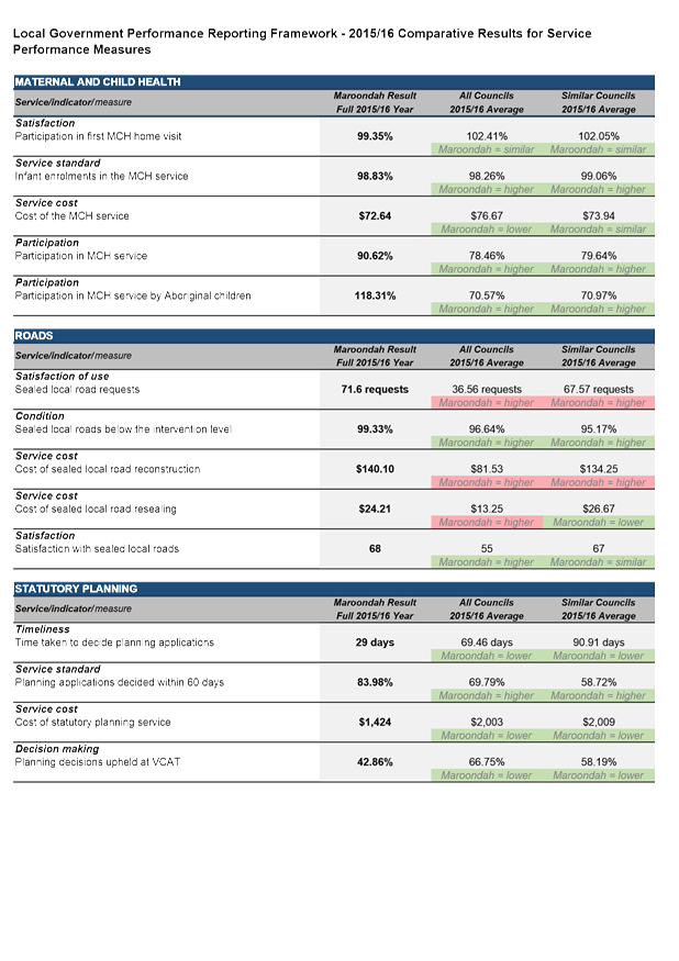
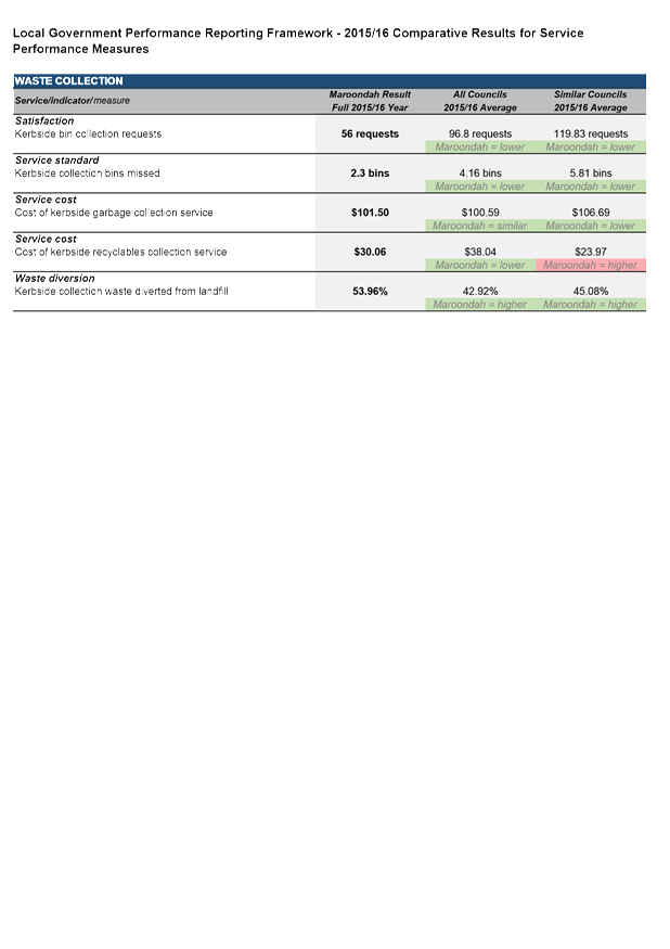
|
DIRECTOR Planning & Community – Phil Turner
|
|
|
|
Fenced Dog Parks for
Maroondah
|
Item 4
|
Purpose
To update Council on the further public consultation and
other works completed on the design of a fenced dog park at Eastfield Park,
including a preferred location and to seek approval to progress to the stage of
tendering for construction of the park.
Strategic /
policy issues
The following directions contained in Maroondah 2040:
Our Future Together and the Council Plan 2013-2017 (Year 3: 2015-2016) provide
the strategic framework that underpins the purpose of this report.
Outcome Area:
A safe, healthy, and active community
In 2040, Maroondah is a safe, healthy, and active community
with local opportunities provided for people of all ages and abilities to have
high levels of social, emotional, and physical wellbeing.
Our Vision: Maroondah will be a
vibrant and diverse city with a healthy and active community, living in green
and leafy neighbourhoods which are connected to thriving and accessible
activity centres contributing to a prosperous economy within a safe, inclusive,
and sustainable environment
Key Directions 2013 – 2017:
A HEALTHY COMMUNITY
1.17 Promote healthy eating and
physical activity by supporting education initiatives and providing a diverse
range of accessible open spaces, and recreation facilities and services
AN ACTIVE COMMUNITY
1.18 Enhance and
maintain an integrated and connected network of passive and active open space
to promote community health and wellbeing
1.19 Provide a range
of integrated recreation and leisure facilities that meet the needs of all ages
and abilities
1.21 Support and
empower local community groups, sporting clubs and special interest groups
across Maroondah
AN INCLUSIVE COMMUNITY
7.8 Support
all ages and population groups to be valued, connected, supported, and
empowered within their local community through the provision and coordination
of accessible services, programming, and facilities
A DIVERSE COMMUNITY
7.11 Ensure the needs of
community members from all ages, backgrounds and lifestyles are considered in
planning for local services, programs, and infrastructure
Background
A report was presented to Council at its meeting of 7
September, 2015 outlining a proposal for one or two fenced dog parks within
Maroondah.
The report proposed that Council consider the development of
one or two sites in the near term to cater for the increasing community demand
and to ensure ease of geographic access for as many users as possible. These
sites would ideally be situated in the north and south of the municipality, and
by providing more than one site, there is flexibility in Council’s
ability to provide varying sizes and attributes of each park being developed,
i.e. a larger regional park and a smaller and more basic local park.
The report considered several sites within Maroondah and
recommended that two sites were preferred options. These sites were Eastfield
Park for a larger regional facility and Quambee Reserve for a smaller more
basic park. Further recommendations were to consult with the community
regarding the suitability of the preferred parks and what attributes were
wanted in a fenced dog park.
A further report was presented to Council on 27 June 2016
with the outcomes of the community consultation with the options and
implications for progressing the construction of such facilities. Council
authorised consultation with the community on the location and features of the
facility within the park.
This report provides the relevant information on the
specific location, features and costs along with timing to build the fenced dog
park at Eastfield Park. Council Officers are continuing to review options
for a smaller park at Quambee Reserve in North Ringwood.
Issue /
discussion
Previous Consultation
Council undertook initial formal consultation in late 2015
through direct discussions at the Maroondah Festival Café Consult tent,
via an on-line survey and by mail out to sporting clubs and other community
groups who are key users of the Quambee Reserve and Eastfield Park.
The data was categorised into 3 themes:
· Dog park – Supported/Not supported
· Attributes – What attributes should be in a dog park
· Location – Quambee Reserve and or Eastfield Park
A total of 301 submissions were received following this
consultation and have been grouped into the following three categories which
are shown below.
Online survey = 92 Submissions
Café Consult = 184 Submissions
Written correspondence = 25 Submissions
The following is a
breakdown of the submissions received as per the 3 themes shown above.
Dog Park supported/not supported – Supported
289 / Not supported 12
Attributes – The top five attributes that the
community wanted in a dog park were;
· Water fountains
· Shaded areas
· Bins
· Seating
· Open Spaces
Location – Quambee Reserve and or Eastfield Park
27 submissions were received on Location from those parties
Council wrote to directly.
· Quambee Reserve – 7 submissions received in favour,3 against.
· Eastfield Park – 14 submissions received in favour, 3 against
Current Situation and Consultation
The Design
Council has engaged a consultant to design a draft concept
plan within Eastfield Park. The preferred location has been identified as
fronting Eastfield Road on the south side of the park.
The first dog park in Maroondah is proposed to be a larger
“regional” fenced dog park which can cater for a wider variety of
users and provide a more interactive and diverse recreation opportunity for
dogs and their owners. Plans for the proposal can be found at Attachment 1.
Current Consultation
Council undertook initial consultation in 2015 about the
general desire to construct a fenced dog park within Maroondah and the types of
attributes that the community would like within a fenced dog park.
The most recent community consultation took place between
Monday 31 October until Sunday 13 November 2016 and it related solely to a
facility at Eastfield Park. Council conducted this consultation by placing the
draft concept plan on its website and asked the community to provide comment on
the plan and location (Refer to Attachment 2 for the website consultation).
Council also communicated this information via its social
forums on Facebook and through media outlets in the Maroondah Leader with a
media release and on local radio (Refer Attachment 3 for media release).
Finally, Council also wrote to the surrounding residents of
Eastfield Park asking for their feedback and included a copy of the concept
plan. Council also met with several of the Eastfield Park users in face to face
meetings and showed them the plans and discussed any of their concerns (Refer
to Attachment 4 for letter to residents and users of Eastfield Park).
From this consultation the following information has been
collated:
Written submissions received = 36
· Positive Support = 30
· Negative Support = 6
Addressing Concerns of the Community
The
main issues raised in the submissions are outlined below:
Fenced Dog Park next to trotting track
Council
Officers worked closely with both the harness and pony clubs throughout the
design and siting phases for planning the fenced dog park. Significantly
both user groups are supportive of the proposal.
Advice
received from the design consultant for the park is that many dogs will not be
distracted or interested in the presence of horses nearby, and so most dogs
will simply utilise the sensory and play objects in the space along with
socialising with other dogs and ignore horses in the distance. For those
dogs prone to being distracted by a horse in the distance, the dogs line of
sight towards the horse track is proposed to be screened. And as such the park
has been designed to ensure visual barriers such as the existing and new planting
along with the other structural features in the park will in the main block
vision of the horses.
Finally,
it should also be noted that dog owners utilising the fenced dog park will do
so on several conditions of entry to the facility. Signage will indicate that
regardless of the area being enclosed owners must accompany their dogs and
remain in effective control to ensure the dogs socialise and behave in a manner
that does not impact negatively on other animals or people.
Fence height of 1200mm is too small
Several
concerns have been raised regarding the proposed 1.2 metre fence height, and
the need to increase this fence height for safety and security of the
space. Council Officers have discussed this issue with the design
consultant for the park and several industry experts on dogs. Advice
received has been that the park space would benefit from a higher fence on the
rear fence of the dog park (parallel with the trotting track) to around 1.6
metres. This feedback also recognised that fencing was a final measure
and that the visual screening coupled with the attractions for dogs inside the
fenced dog park will be by far the most effective means of minimising the risk
of dogs trying to jump over the fences.
The dog park is next to a children’s playground
The
fenced dog park has been provided with two separate entrances and neither
requires dogs and their owners to traverse through the children’s play
area. There will of course be times that people pass by or are near the
plays space with their dogs. It should however be noted that owners walking
their dogs in and or near Eastfield Park or Eastfield Road must already have
their dogs on a leash and under effective control. Signage has just been
renewed throughout this area highlighting this dog on leash requirement. In
addition to this general requirement Council also has an order in place right
across the municipality specifying that dogs must always be on leash within 15
metres of “playgrounds or children’s play equipment”.
Funding and ongoing maintenance of the dog park
The
fenced dog park has been designed to be low maintenance and durable.
Along with the park design Council has developed a management plan that
identifies a broad range of activities that will be required to ensure this
space is well utilised, safe, and maintained to a good standard. This
plan addresses matters such as education and enforcement activities, signage,
patrols by Local Laws officers, signage, and ongoing maintenance by Operations
staff. All aspects of the management plans can be absorbed within
existing budgets.
Parking access
As
the facility is proposed to be located adjoining the side road to Eastfield
Road there are already substantial numbers of on street car parking spaces that
are not used and will give excellent access to the facility. These spaces
coupled with those in the park will be more than sufficient to cater for the
likely demand. Council’s traffic engineers have also considered the
safety and access implications of extra parking and traffic, including parking
for disabled persons, and have advised that the proposed parking and traffic
matters are well resolved.
Construction Details, Maintenance, and Management Plan
The costs associated to construct the fenced dog park are
taken from the design of the concept plan. Councils Assets and Open Space teams
have reviewed the estimated costs for construction of the facility and have
advised the likely cost will be between $180,000 and $200,000 dollars. In
addition to this estimate it is recognised that higher fencing at around 1.6
metres in height will add some additional expense that will mean some redesign
to ensure the total cost does not exceed this amount. As a budget for
this project has been set aside for expenditure of $200,000 in the 2016/17
financial year, the estimate for construction is within the project
budget.
A Management Plan for the fenced dog park is being finalised
with internal Council departments. This will ensure Council departments
responsible for the ongoing management and success of the of the park will have
clear roles and responsibilities.
Some of the protocols in the management plan to be
considered but not limited to:
· Waste management practices
· What are the minimum age requirements set to enter the park with a
dog
· Ratio of dogs per person
· Operating hours of park
· Restriction of use of park in bad weather
· Alcohol not to be taken into park
· Community education of the park
· Appropriate signage for users of the park
· Reporting of incidents to Council
· Noise issues
Construction Timing
Should Council resolve to proceed with the proposed plan,
the estimated timeline for construction would begin in March 2017 and be
completed in mid-2017.
Financial /
economic issues
Covered within existing budgets.
Environmental
/ amenity issues
Not Applicable
Social /
community issues
There are numerous benefits from the provision of
fenced dog parks for both dogs and their owners and some of these include:
· Adding to the diversity of recreational opportunities for residents
· Provision of a safe social environment where a variety of people and
their dogs can recreate together
· Providing opportunities for older people and people with restricted
mobility/disabilities with an accessible and safe place to exercise their dog
· Encouraging people to become active and exercise their dogs
· Dogs and their owners can be separate from people who do not want to
interact with dogs
· Provision of a focal point for community education and training
around responsible pet ownership
· Separation and safe spaces for dogs that does not conflict with
other park activities
· Allowing dogs access to parkland but protecting their sensitive
environments such as bushland areas
Conclusion
Given the substantial community support for a fenced dog
park and well resolved design of such a facility at Eastfield Park, it is
recommended that Council approve the construction of a “regional”
fenced dog park at the front of Eastfield Park, with costs associated to come
from within existing operating department budgets.
Attachments
|
1.⇩
|
Maroondah
Dog Park
|
|
2.⇩
|
Website
|
|
3.⇩
|
Media
|
|
4.⇩
|
Letter
|
CONFIDENTIALITY
Not Applicable
|
RECOMMENDATION
that council APPROVES THE CONSTRUCTION OF A
FENCED DOG PARK AT EASTFIELD PARK generally in accordance with the plans
referred to in attachment 2 to this report
|
|
ATTACHMENT No: 1 - Maroondah Dog Park
|
|
Item 4
|
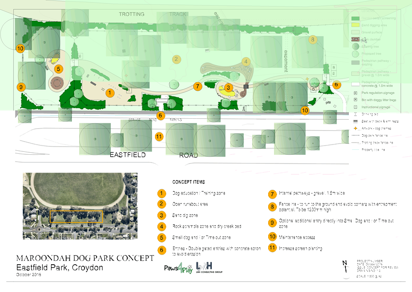
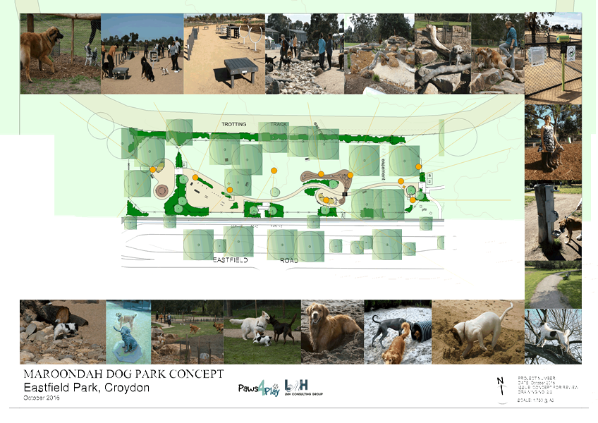
|
ATTACHMENT No: 2 - Website
|
|
Item 4
|
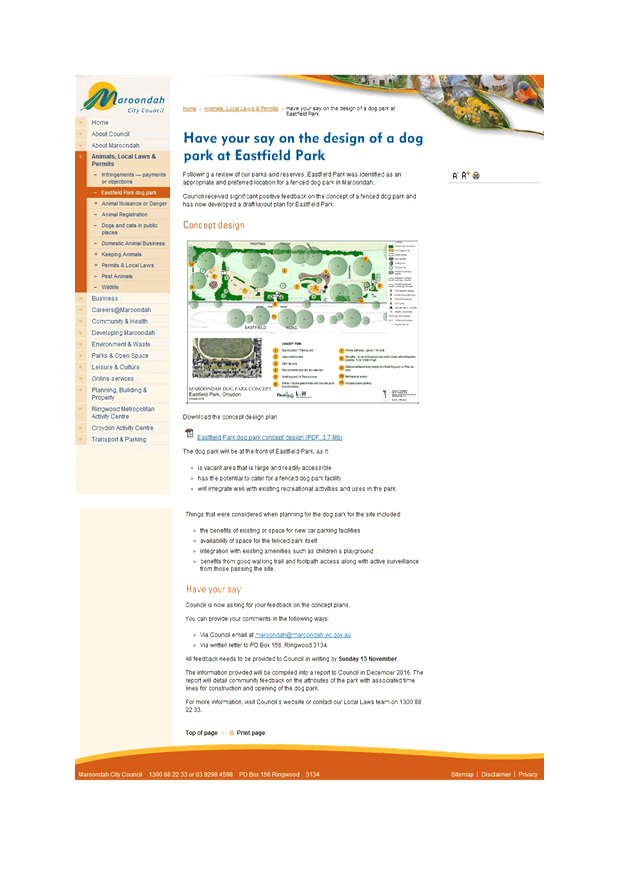
|
ATTACHMENT No: 3 - Media
|
|
Item 4
|

|
ATTACHMENT No: 4 - Letter
|
|
Item 4
|
|
Village School Licence Agreement and
Transfer of Land
|
ITEM 1
|
Background
Agreement has been reached between Council and the Village
School Inc in relation to two property matters concerning the school’s
land at 9 Holloway Road, Croydon North.
1. A
Council pathway is partly on school land and the school has agreed to sell the
land to Council for $5,000 plus GST.
2. A
Council pipeline to pipe recycled water from the nearby Yarra Valley Water
recycling plant to nearby Hughes Park and Brushy Park will now be subject to a
Licence Agreement between the School and Council. A licence fee of $10,000 plus
GST commencing 1 July 2012 for period of 25 years.
Attachments
Not Applicable
CONFIDENTIALITY
Not Applicable
|
RECOMMENDATION
That council signs and seals:
1. THE TRANSFER OF LAND FOR THE
PROPERTY DESCRIBED AS LOT R1 ON PS715646N
2. THE LICENCE AGREEMENT TO GRANT
COUNCIL A LICENCE TO UTILISE AND ACCESS THE PIPELINE UPON THE SCHOOL’S
LAND COMPRISED IN LOT 1 ON TITLE PLAN 211706T CERTIFICATE OF TITLE VOLUME
10348 FOLIO 951
|
1 The speed at which 85% of vehicles
are travelling at or below
1 The speed at which 85% of vehicles
are travelling at or below